
Conventional Symbols Direction and Bearing – SS1 Geography Lesson Note (Third Term)
Download this term · ₦1,000Lesson note at a glance
- Subject
- Geography
- Class
- SS1
- Term
- Third Term
- Topic
- Conventional Symbols Direction and Bearing
- Order
- Topic 7 of 8 this term
- Reading time
- 5 min
Direction tells where one place lies from another, and it is given using compass points. Bearing gives the same information as an angle in degrees, measured clockwise from North with a protractor.
Behavioural objectives
- Describe the common conventional symbols used on maps.
- State the four cardinal points and the eight compass points used to measure direction accurately.
- Measure the direction of one place from another on a map.
- Explain what bearing is.
- Measure the bearing of one place from another using a ruler and a protractor.
What are conventional symbols?
Conventional symbols are small signs, lines, colours and shapes that stand for real features on a map.
- Why they are used: the map has little space, so symbols show features without long written descriptions.
- Key or legend: a box on the map that explains what each symbol means.
- Rule: symbols can differ slightly from one map to another, so always read the key first.
What are the kinds of conventional symbols?
There are three kinds of conventional symbols: point symbols, line symbols and area symbols.
- Point symbols: a dot or small sign for a feature at one spot, such as a settlement.
- Line symbols: a line for a long, narrow feature, such as a river, railway or footpath.
- Area symbols: a colour or pattern covering a space, such as a lake or vegetation.
What are examples of conventional symbols?
| Feature | How it is commonly shown |
|---|---|
| River | A blue line, often winding |
| Lake or sea | A blue area |
| Railway | A line with short cross bars |
| Footpath | A dotted or broken line |
| Contour lines (relief) | Brown lines joining places of equal height |
| Vegetation | Green colour or small tree signs |
| Settlement | Black dots or small black blocks |
What is direction?
Direction is the way one place or object lies from another.
- Compass points: the named points used to express direction.
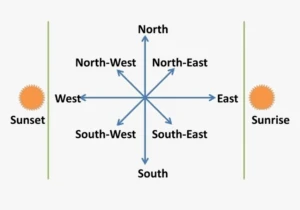
- Four cardinal points: North, South, East and West.
- Eight points: the four cardinal points plus North-East, South-East, South-West and North-West, used for better accuracy.
- Angle between cardinal points: each neighbouring pair, such as North and East, is 90° apart.
What are the eight compass points?
The eight compass points are North, North-East, East, South-East, South, South-West, West and North-West.
| Point | Short form | Position |
|---|---|---|
| North | N | Cardinal point, at the top of the map |
| North-East | NE | Halfway between North and East |
| East | E | Cardinal point, to the right |
| South-East | SE | Halfway between South and East |
| South | S | Cardinal point, at the bottom |
| South-West | SW | Halfway between South and West |
| West | W | Cardinal point, to the left |
| North-West | NW | Halfway between North and West |
How do you measure direction on a map?
To measure direction, join the two places with a straight line and read the compass point it follows from the reference point.
- Locate the two places involved on the map.
- Mark the reference point, which is the place you are measuring from.
- Draw the four cardinal points (a North line and an East-West line) at the reference point.
- Use a ruler to join the reference point to the other place.
- Read the compass point that the line falls on or lies closest to. That is the direction.
- Example: if town B lies halfway between North and East of town A, then B is North-East of A.
- Tip: say the direction as “B is North-East of A”, with the reference point last.
What is bearing?
Bearing is the direction of one place from another, given as an angle in degrees measured clockwise from North.
- Starting line: the angle is always measured from North.
- Turning direction: the angle is measured clockwise, the way the hands of a clock move.
- Range: bearings run from 000° up to 360°.
- Instrument: a protractor.
- Writing it: bearings are usually written with three figures, for example 045° or 270°.
What are the bearings of the eight points?
The eight compass points are 45° apart, starting from North at 000°.
| Point | Bearing |
|---|---|
| North | 000° (or 360°) |
| North-East | 045° |
| East | 090° |
| South-East | 135° |
| South | 180° |
| South-West | 225° |
| West | 270° |
| North-West | 315° |
How do you measure bearing on a map?
To measure bearing, draw a North line at the reference point and read the clockwise angle to the line joining the two places.
- Locate the two places involved on the map.
- Mark the reference point, because you want the bearing of the other place from it.
- Draw a North line through the reference point, pointing to the top of the map.
- Use a ruler to draw a straight line from the reference point to the other place.
- Place the centre of the protractor on the reference point, with its zero line along the North line.
- Read the angle from North, clockwise, to the line you drew. That angle is the bearing.
- Tip: if the place lies to the West of the North line, measure the angle anticlockwise from North, then subtract it from 360°.
- Example 1: a bearing of 060° is 60° clockwise from North, so the place lies between North-East and East, nearer East.
- Example 2: a bearing of 240° lies between 180° (South) and 270° (West), so the place is South-West.
- Example 3: a bearing of 300° lies between 270° (West) and 360° (North), so the place is North-West.
What is the difference between direction and bearing?
Direction names a place’s position using compass points, while bearing gives it as an angle from North.
- Direction: the general way a place lies from another, such as North-East.
- Bearing: the exact angle clockwise from North, such as 045°.
| Feature | Direction | Bearing |
|---|---|---|
| Expressed as | Compass points, such as North-East | Degrees, such as 045° |
| Instrument | Ruler and compass points | Ruler and protractor |
| Accuracy | General | More exact |
Evaluation
- Name the four cardinal points and the four points that lie between them.
- State the steps for measuring the direction of one place from another on a map.
- What is bearing, and which instrument is used to measure it?
- What is the bearing of South-West, and what is the bearing of North-West?
- Why does a map have a key, and how are a river and a railway commonly shown?
Assignment
Draw the eight compass points, label each with its short form and its bearing, and write the steps for measuring a bearing on a map.
This term's Geography topics
SS1 Third Term · 8 topics
Get Geography as PDF and Word
Every week of SS1 Geography, Third Term, formatted and ready to print. Ad-free, and the copy lock comes off.
Get this term Card, bank transfer, USSD or OPay
SS1 Geography Lesson Notes for Other Topics

Nigeria: Transportation
Read the full lesson note.
Nigeria: Communication
Read the full lesson note.

Manufacturing Industries In Nigeria
Read the full lesson note.

Nigeria: Commercial Activities
Read the full lesson note.

ECOWAS
Read the full lesson note.
Map Reading And Measurements Of Distances On Maps
Read the full lesson note.

Basic Concepts And Component Of GIS
Read the full lesson note.
Geography: An Introduction
Read the full lesson note.

The Earth's Rotation
Read the full lesson note.

The Earth's Revolution
Read the full lesson note.

Latitude & Longitude
Read the full lesson note.

The Earth's Structure
Read the full lesson note.

Rocks
Read the full lesson note.

Mountains
Read the full lesson note.

Lowlands
Read the full lesson note.
Lesson Notes for Other Classes

SS2 Lesson Note
The complete lesson note to guide your studies.

SS3 Lesson Note
The complete lesson note to guide your studies.
