
Latitude & Longitude – SS1 Geography Lesson Note (First Term)
Lesson note at a glance
- Class
- SS1
- Subject
- Geography
- Term
- First Term
- Reading time
- 6 min
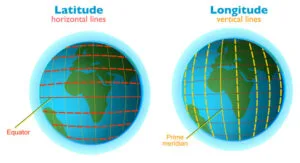
Latitude and longitude are imaginary lines drawn on the globe to locate places on the earth’s surface.
- Latitude: the angular distance of a place north or south of the equator.
- Longitude: the angular distance of a place east or west of the Greenwich Meridian.
Behavioural objectives
By the end of the lesson, students should be able to:
- define latitude and longitude;
- list the important lines of latitude and longitude;
- state the uses of lines of latitude and longitude;
- state the similarities and differences between latitude and longitude;
- distinguish between a great circle and a small circle;
- use longitude to find the time difference between two places.
What is latitude?
Latitude is the angular distance of a point on the earth’s surface north or south of the equator, measured in degrees from the centre of the earth.
- Parallels: lines of latitude run parallel to the equator, so they are also called parallels.
- The Equator: the line at 0° that divides the earth into the Northern and Southern Hemispheres.
- Range: latitude runs from 0° at the Equator to 90°N and 90°S at the poles.
- Direction: the lines run west to east around the globe.
What are the important lines of latitude?
There are seven important lines of latitude: the Equator, the two tropics, the two polar circles and the two poles.
| Line | Value | Note |
|---|---|---|
| The Equator | 0° | The starting line for measuring latitude. |
| Tropic of Cancer | 23½°N | The northern limit of the tropics. |
| Tropic of Capricorn | 23½°S | The southern limit of the tropics. |
| Arctic Circle | 66½°N | Marks the northern polar region. |
| Antarctic Circle | 66½°S | Marks the southern polar region. |
| North Pole | 90°N | A single point, the northern end of the earth’s axis. |
| South Pole | 90°S | A single point, the southern end of the earth’s axis. |
What are the uses of lines of latitude?
Lines of latitude are used to fix the position of a place north or south of the equator.
- They help to determine the exact location of a place on an atlas map.
- They help to calculate the distance between two places on the earth’s surface.
- They mark the main heat zones of the earth, bounded by the tropics and the polar circles.
- Nigeria’s position: Nigeria lies roughly between latitudes 4°N and 14°N, so it is in the tropics.
What is longitude?
Longitude is the angular distance of a point east or west of the Greenwich Meridian, measured in degrees.
- Meridians: all lines of longitude are called meridians.
- Direction: they run from north to south, from pole to pole, at right angles to the parallels.
- Prime Meridian: the meridian at 0°, also called the Greenwich Meridian, passes through Greenwich in London and through Ghana.
- Range: longitude runs from 0° to 180°E and from 0° to 180°W.
- Nigeria’s position: Nigeria lies roughly between longitudes 3°E and 15°E.
What are the important lines of longitude?
- Long. 0° (Prime Meridian)
- Long. 45°E
- Long. 45°W
- Long. 90°E
- Long. 90°W
- Long. 180° (the 180° meridian, which is neither east nor west)
What are the uses of lines of longitude?
Lines of longitude are used to fix the position of a place east or west of the Greenwich Meridian.
- They help to calculate local time.
- They help to determine the exact location of places on an atlas map.
How does longitude help to calculate time?
The earth turns through 360° in 24 hours, so every 15° of longitude is a difference of one hour.
- 15° of longitude: equals 1 hour.
- 1° of longitude: equals 4 minutes.
- East of Greenwich: time is ahead, so add the difference.
- West of Greenwich: time is behind, so subtract the difference.
Steps for finding the time at another place
- Find the difference in longitude between the two places.
- Divide the difference by 15 to get the time difference in hours.
- Add the time difference if the place is east. Subtract it if the place is west.
Worked examples
- 45°E: 45 ÷ 15 = 3 hours ahead. When it is 12 noon at Greenwich, it is 3:00 p.m. there.
- 90°W: 90 ÷ 15 = 6 hours behind. When it is 12 noon at Greenwich, it is 6:00 a.m. there.
How are lines of latitude and longitude alike and different?
Lines of latitude (parallels) run west to east and measure position north or south, while lines of longitude (meridians) run north to south and measure position east or west.
What are the similarities between latitude and longitude?
- Both are used for the location of places on the map.
- Both are numbered in degrees.
- Both are imaginary lines drawn on the globe.
- Both contain great circles.
What are the differences between latitude and longitude?
| SN | Lines of latitude | Lines of longitude |
|---|---|---|
| 1 | The Equator is the only great circle. | Opposite meridians together form many great circles. |
| 2 | Lines are shorter towards the poles. | Lines are of the same length. |
| 3 | They run from west to east. | They run from north to south. |
| 4 | Lines are parallel to each other. | Lines are not parallel to each other but converge at the poles. |
| 5 | The lines are called parallels. | The lines are called meridians. |
| 6 | Lines are used for measuring distance. | Lines are used for calculating local time. |
| 7 | The Equator is the reference line. | The Greenwich Meridian is the reference line. |
| 8 | Latitude measures up to 180°, that is, 90°N to 90°S. | Longitude measures up to 360°, that is, 180°W to 180°E. |
What are a great circle and a small circle?
A great circle is a circle on the earth’s surface that divides the earth into two equal halves, while a small circle does not.
What is a great circle?
- Definition: any circle that divides the earth into two equal halves, or hemispheres.
- Centre: the centre of a great circle is also the centre of the earth.
- Latitude example: the Equator is the only line of latitude that is a great circle.
- Longitude example: two opposite meridians together make a great circle.
- Use: the shortest route between two points on the globe lies along a great circle, so aircraft follow it.
Examples of great circles formed by opposite meridians:
- Long. 0° with long. 180°.
- Long. 30°W with long. 150°E.
- Long. 110°W with long. 70°E.
What is a small circle?
- Definition: any circle that does not divide the earth into two equal halves.
- Latitude: all lines of latitude are small circles except the Equator.
- Examples: the Tropic of Cancer, the Tropic of Capricorn, the Arctic Circle and the Antarctic Circle.
Evaluation
- Define latitude and longitude.
- List the seven important lines of latitude and give their values.
- State two uses of lines of longitude.
- State three differences between lines of latitude and lines of longitude.
- Distinguish between a great circle and a small circle.
Assignment
Answer all five questions below, choosing the correct option (a), (b) or (c).
- Lines of longitude can best be described as (a) the angular distance of a place north or south of the equator (b) semi-circle on the globe (c) imaginary lines on the earth’s surface joining the north and south poles.
- The angular distance of a point on the earth’s surface measured in degrees from the centre of the earth is known as (a) latitude (b) longitude (c) international date line.
- The shortest flying route between any two points on the earth’s surface lies along the (a) Tropic of Capricorn (b) Tropic of Cancer (c) great circle.
- A great circle can be described as (a) a line of longitude (b) a line of latitude (c) the shortest distance between two points on the globe.
- The following are the similarities between lines of longitude and latitude except (a) both are used to calculate the local time of a place (b) both are numbered in degrees (c) both contain great circles.
This term's Geography topics
SS1 First Term · 9 topics
SS1 Geography Lesson Notes for Other Topics
Geography: An Introduction
Read the full lesson note.

The Earth's Rotation
Read the full lesson note.
The Earth's Revolution
Read the full lesson note.

The Earth's Structure
Read the full lesson note.
Rocks
Read the full lesson note.

Mountains
Read the full lesson note.
Lowlands
Read the full lesson note.
The Environment - Ecosystem & Its Component
Read the full lesson note.
Nigeria: Location And Position
Read the full lesson note.
Physical Setting Of Nigeria: Relief And Drainage
Read the full lesson note.

The Nigerian Climate
Read the full lesson note.
Nigeria Vegetation
Read the full lesson note.
Nigerian Population
Read the full lesson note.
Nigeria Resources
Read the full lesson note.
Agriculture in Nigeria
Read the full lesson note.
Lesson Notes for Other Classes
SS2 Lesson Note
The complete lesson note to guide your studies.
SS3 Lesson Note
The complete lesson note to guide your studies.
