
Vegetation – SS2 Geography Lesson Note (First Term)
Lesson note at a glance
- Class
- SS2
- Subject
- Geography
- Term
- First Term
- Reading time
- 5 min
Vegetation is the plant cover of an area, and soil is the thin top layer of the earth’s crust on which plants grow. Nigeria has three major vegetation zones (forest, savanna and montane) and four major soil zones (laterite, sandy, forest and alluvial).
Behavioural objectives
- Name the three major vegetation zones of Nigeria and their subdivisions.
- Describe the features of each vegetation zone and state where it is found.
- Define soil.
- List the four major soil zones of Nigeria.
- Describe each soil zone and state where it is found.
- Link each soil zone to its vegetation or its cause of formation.
What are the vegetation zones of Nigeria?
Nigeria has three major vegetation zones: forest, savanna and montane.
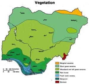
- Forest zone: an area covered mainly by trees, found in the south.
- Savanna zone: an area covered mainly by grasses, with few trees, found in the middle and north.
- Montane vegetation: vegetation of highland areas, such as Jos and Adamawa.
What factors affect vegetation?
Vegetation is affected mainly by climate, relief, soil and human activity.
- Rainfall: heavy rainfall gives forest, while low rainfall gives grassland or thorny shrubs.
- Temperature: high temperature with moisture supports dense growth, while cooler highlands support different plants.
- Relief: height above sea level changes the weather and the plants that grow.
- Soil: fertile, deep soil supports bigger plants than thin, dry soil.
- Human activity: farming, bush burning and logging change the natural plant cover.
What is the forest zone?
The forest zone is the part of southern Nigeria covered mainly by trees, and it has two subdivisions: mangrove swamp forest and rainforest.
Mangrove swamp forest
- Location: along the coast and in the Niger Delta.
- Types: salt water swamp and freshwater swamp.
- Plants: mangrove trees with stilt roots that hold them in soft, wet mud.
- Rainfall: very heavy.
Rainforest
- Location: inland from the coast, where rainfall is heavy.
- Structure: tall trees growing in layers, with a dense canopy that blocks much sunlight.
- Leaves: broad and mostly evergreen, so the forest stays green all year.
- Trees: hardwoods such as iroko, mahogany and obeche.
- Uses: timber, and farm crops such as cocoa, oil palm and rubber.
What is the savanna zone?
The savanna zone is the part of middle and northern Nigeria covered mainly by grasses with scattered trees, and it has three subdivisions: Guinea, Sudan and Sahel savanna.
Guinea savanna
- Location: the middle belt.
- Plants: tall grasses with scattered trees.
- Crops: yam, maize and rice are grown here.
Sudan savanna
- Location: north of the Guinea savanna.
- Plants: shorter grasses and fewer trees.
- Crops: millet, guinea corn and groundnut are grown here.
Sahel savanna
- Location: the extreme north.
- Plants: short, thin grass and thorny shrubs, because rainfall is very low.
- Land use: mainly cattle rearing and the growing of millet.
What is montane vegetation?
Montane vegetation is the plant cover of highland areas, which differs from that of the lowlands around.
- Location: highland areas such as Jos Plateau, Adamawa highlands and Mambilla Plateau.
- Reason: height makes the weather cooler, so the plants differ from those of the lowlands around.
- Plants: grasses and trees that suit cooler, wetter highland conditions.
How do the vegetation zones compare?
The table below compares the plants, rainfall and location of each zone explained above.
| Zone | Main plants | Rainfall | General location |
|---|---|---|---|
| Mangrove swamp forest | Trees with stilt roots | Very heavy | Coast and Niger Delta |
| Rainforest | Tall trees in layers | Heavy | South |
| Guinea savanna | Tall grass, scattered trees | Moderate | Middle belt |
| Sudan savanna | Short grass, few trees | Low | North |
| Sahel savanna | Thin grass, thorny shrubs | Very low | Extreme north |
| Montane | Highland grass and trees | Varies with height | Jos Plateau, Adamawa |
What is soil?
Soil is the thin uppermost layer of the earth’s crust on which plants grow.
- Humus: dark matter in soil formed from decayed plants and animals.
- Leaching: the washing down of soil nutrients by rainwater.
- Alluvium: fine soil and silt deposited by rivers.
What are the soil zones of Nigeria?
Soils in Nigeria are grouped into four major zones: laterite, sandy, forest and alluvial.
- Zone of laterite soil
- Zone of sandy soil
- Zone of forest soil
- Zone of alluvial soil
1. Zone of laterite soil
- Location: the interior of Nigeria, in places such as Jos, Makurdi, Minna, Enugu and Abuja.
- Vegetation: associated with the Guinea savanna.
- Cause of formation: heavy leaching by rainfall.
- Colour: usually reddish because of the iron it contains.
- Feature: low in humus and nutrients, because leaching removes them.
2. Zone of sandy soil
- Location: the extreme north, in places like Sokoto, Katsina, Kano, Damaturu and Maiduguri.
- Vegetation: associated with the Sudan and Sahel savanna.
- Cause of formation: dryness and the deposition of sand by wind.
- Feature: loose and light, so it holds little water and few nutrients.
3. Zone of forest soil
- Location: the southern belt and south-west, in places like Ibadan, Akure, Benin City, Ogun, Anambra and Imo.
- Vegetation: associated with forest vegetation.
- Cause of formation: fallen leaves decay and make the soil rich in humus.
- Feature: dark and fertile, so it suits tree crops such as cocoa and oil palm.
4. Zone of alluvial soil
- Location: around Ilorin, Lokoja and the Niger Delta areas of Warri, Port Harcourt and Calabar.
- Cause of formation: fine alluvial deposits laid down at the lower course of a river.
- Feature: fine and fertile, and found on low, flat land near rivers.
How do the soil zones compare?
The table below links each soil zone explained above to its places, vegetation or cause of formation.
| Soil zone | Example places | Linked vegetation or cause |
|---|---|---|
| Laterite | Jos, Makurdi, Minna, Enugu, Abuja | Guinea savanna; leaching; iron content |
| Sandy | Sokoto, Katsina, Kano, Damaturu, Maiduguri | Sudan and Sahel savanna; dryness; wind-blown sand |
| Forest | Ibadan, Akure, Benin City | Forest vegetation; humus from decayed leaves |
| Alluvial | Ilorin, Lokoja, Warri, Port Harcourt, Calabar | River deposits at the lower course |
Evaluation
- Name the three major vegetation zones of Nigeria.
- List the three subdivisions of the savanna zone.
- Define soil.
- Why is laterite soil usually reddish?
- Name two places where sandy soil is found and the vegetation it is associated with.
Assignment
- Draw a table with four columns: soil zone, two places where it is found, linked vegetation or cause of formation, and one feature. Fill it in for laterite, sandy, forest and alluvial soils.
This term's Geography topics
SS2 First Term · 10 topics
SS2 Geography Lesson Notes for Other Topics

Action Of Running Water
Read the full lesson note.

Action Of Wind
Read the full lesson note.

Glacial Action
Read the full lesson note.

Action Of Wave
Read the full lesson note.

Climate & Climate Classification
Read the full lesson note.

Climate & Climate Classification II
Read the full lesson note.
Environmental Resources
Read the full lesson note.

Renewable And Non-Refundable Resources
Read the full lesson note.

Environmental Problems
Read the full lesson note.

Environmental Conservation
Read the full lesson note.

Transportation In Nigeria
Read the full lesson note.

Manufacturing Companies In Nigeria
Read the full lesson note.

Commercial Activities In Nigeria
Read the full lesson note.

World Population I
Read the full lesson note.

World Population II
Read the full lesson note.
Lesson Notes for Other Classes

SS1 Lesson Note
The complete lesson note to guide your studies.

SS3 Lesson Note
The complete lesson note to guide your studies.
