
Action of Running Water – SS2 Geography Lesson Note (First Term)
Lesson note at a glance
- Class
- SS2
- Subject
- Geography
- Term
- First Term
- Reading time
- 7 min
Running water is the flow of water in rivers, and it erodes, transports and deposits materials as it moves from source to mouth.
Behavioural objectives
By the end of the lesson, students should be able to:
- Explain the terms associated with rivers, such as source, mouth, confluence, tributary and river regime.
- State the factors that affect the velocity of a river.
- Describe the upper, middle and lower courses of a river and name the features found in each.
- Describe the processes of river erosion and river transportation.
- Identify the types of drainage pattern and state the importance of rivers.
What are the terms associated with rivers?
These are the ten basic terms used to describe a river and its work.
- Source: the place where a river begins, usually in highlands.
- Course: the path or channel through which a river flows.
- Mouth: the place where a river ends by entering a sea, ocean or lake.
- River basin (catchment area): all the land drained by a river and its tributaries.
- Watershed (water divide): the highland that separates two river basins. Rivers take their sources from it.
- River regime: the seasonal change in the volume of water in a river during a year.
- Confluence: the meeting point of two rivers, for example the Niger and Benue at Lokoja.
- Tributary: a smaller river or stream that joins a larger river.
- Distributary: a channel formed when a river divides as it flows into the sea. Distributaries are found in deltas.
- River energy: the velocity of a river. It decides how much the river can erode and carry.
What are the types of river regime?
There are two types of river regime: single and double.
- Single regime: one period of high water volume and one period of low volume in a year.
- Double regime: two distinct periods of high water volume in a year.
Why is knowledge of river regime useful?
- Flood control: people know when high water is likely.
- Water storage: water can be stored for irrigation and human use.
- H.E.P. planning: power production can be planned around water volume.
What factors affect the velocity of a river?
Four main factors affect the velocity of a river.
- Volume of water: a larger volume, for example after heavy rain, gives a faster flow.
- Slope of the valley: a steeper slope gives a faster flow.
- Shape of the valley: a smooth, deep channel flows faster than a wide, rough one.
- Amount and size of materials: a heavy load of large materials slows the river down.
What are the stages of a river?
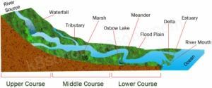
A river has three stages: the upper, middle and lower courses.
- Upper course: also called the mountain course or youthful stage.
- Middle course: also called the valley course or mature stage.
- Lower course: also called the plain course or old stage.
What is the upper course of a river?
The upper course is the first stage of a river, where it flows swiftly down steep highland slopes and cuts downwards.
Characteristics of the upper course
- Position: it marks the source of the river, in highland areas.
- Valley sides: they are steep.
- Flow: the river moves swiftly down the steep slope.
- Dominant work: vertical erosion, which deepens the valley.
What are the processes of river erosion?
There are four processes of river erosion: hydraulic action, corrasion, attrition and solution.
- Hydraulic action: fast-flowing water forces itself under pressure into cracks and joints and enlarges them.
- Corrasion (abrasion): sand, pebbles and boulders carried by the river wear away its sides and floor. This widens and deepens the valley.
- Attrition: the load knocks against itself and the valley floor and sides. Large boulders break into smaller pieces such as pebbles.
- Solution: water chemically dissolves some rocks it touches. For example, rock salt dissolves and is carried away.
What are the features of the upper course?
There are six main features of the upper course.
- V-shaped valley: a narrow valley with steep sides, cut by vertical erosion.
- Interlocking spurs: ridges of highland that jut out from alternate sides of the valley. The river winds around them.
- Gorge: a deep, narrow valley with very steep sides, often formed where a waterfall retreats.
- Rapids and cataracts: places where water rushes over bands of hard rock. Cataracts are larger than rapids.
- Waterfall: a sudden fall of water over a steep step of hard rock.
- River capture (piracy): a stronger river cuts back and takes over the upper part of a weaker neighbouring river.
What is the middle course of a river?
The middle course is the second stage of a river, where sideways erosion widens the valley and transportation dominates.
Characteristics of the middle course
- Erosion: lateral erosion is greater than vertical erosion, so the valley widens.
- Volume: it increases as tributaries add water.
- Load: it increases.
- Main work: transportation, with little deposition.
What are the processes of river transportation?
There are four processes of river transportation: solution, suspension, saltation and traction.
- Solution: dissolved minerals are carried in the water.
- Suspension: fine particles such as clay and silt are carried within the water.
- Saltation: sand and small pebbles bounce along the river bed.
- Traction: large stones and boulders roll or drag along the bed.
What are the features of the middle course?
There are three main features of the middle course.
- Wide V-shaped valley: a valley with gentler, wider sides than in the upper course.
- Meander: a large bend in the river.
- River cliff and slip-off slope: the river cliff is a steep bank on the outside of a bend, where erosion is strong. The slip-off slope is a gentle bank on the inside, where deposition occurs.
What is the lower course of a river?
The lower course is the last stage of a river, where the river flows slowly over flat land and deposits its load.
Characteristics of the lower course
- Main work: deposition of materials.
- Erosion: lateral erosion is still active.
- Gradient: the valley floor is almost flat.
- Speed: it falls sharply.
What are the features of the lower course?
There are five main features of the lower course.
- Flood plain: a flat area on either side of the river, built up from silt left during floods. It is fertile, as in the fadama lands of northern Nigeria.
- Levees: raised banks of coarse material left along the river edge by floods.
- Ox-bow lake: a crescent-shaped lake left when a meander is cut off from the river.
- Braided river: a river that splits into many small channels around islands of deposited material.
- Delta: a low area of deposited material at the river mouth, split by distributaries, as in the Niger Delta.
How do the three courses compare?
| Feature | Upper course | Middle course | Lower course |
|---|---|---|---|
| Main work | Vertical erosion | Lateral erosion and transportation | Deposition |
| Slope | Steep | Gentle | Almost flat |
| Speed | Fast | Moderate | Slow |
| Valley shape | Narrow V-shape | Wide V-shape | Wide flood plain |
| Features | Gorge, waterfall, rapids, interlocking spurs | Meander, river cliff, slip-off slope | Levees, ox-bow lake, delta |
What are the types of drainage pattern?
A drainage pattern is the arrangement of a main river and its tributaries within a basin. There are five types: dendritic, trellised, radial, centripetal and annular.
- Dendritic: tributaries (subsequent rivers) join the main river (consequent river) at an oblique angle. The pattern looks like the branches of a tree and forms on rocks of the same type.
- Trellised: it forms on alternate layers of hard and soft rock. Tributaries follow the rock structure and join the main river at about right angles, giving a rectangular shape.
- Radial: streams flow outward and down from a hill, like the spokes of a bicycle wheel.
- Centripetal: many streams flow from different directions into a lake or basin.
- Annular: the main river almost forms a ring around a highland.
Why are rivers important?
Rivers supply water, power, food, transport and fertile land to people.
- Transportation: rivers carry people and goods by boat.
- Hydroelectric power: H.E.P. is generated where rapids and waterfalls exist.
- Irrigation: rivers supply water for farms.
- Water supply: rivers provide water for domestic and industrial use.
- Fertile soil: flood plains support farming.
- Food: rivers provide fish, prawns and crabs.
- Employment: many people work as fishermen and canoe builders.
- Boundaries: some rivers mark the limits between states, regions and nations.
- Tourism: some rivers attract visitors and earn foreign exchange.
Evaluation
- Define the source, mouth and confluence of a river.
- State four factors that affect the velocity of a river.
- Name the four processes of river erosion and explain any two of them.
- List the features found in the lower course of a river.
- State five ways in which rivers are important to people.
Assignment
With the aid of labelled diagrams, describe how an ox-bow lake is formed and what river capture (piracy) means.
This term's Geography topics
SS2 First Term · 10 topics
SS2 Geography Lesson Notes for Other Topics

Action Of Wind
Read the full lesson note.

Glacial Action
Read the full lesson note.

Action Of Wave
Read the full lesson note.

Climate & Climate Classification
Read the full lesson note.

Climate & Climate Classification II
Read the full lesson note.

Vegetation
Read the full lesson note.
Environmental Resources
Read the full lesson note.
Renewable And Non-Refundable Resources
Read the full lesson note.
Environmental Problems
Read the full lesson note.
Environmental Conservation
Read the full lesson note.
Transportation In Nigeria
Read the full lesson note.

Manufacturing Companies In Nigeria
Read the full lesson note.

Commercial Activities In Nigeria
Read the full lesson note.

World Population I
Read the full lesson note.

World Population II
Read the full lesson note.
Lesson Notes for Other Classes

SS1 Lesson Note
The complete lesson note to guide your studies.
SS3 Lesson Note
The complete lesson note to guide your studies.
