
Africa: Relief and Drainage – SS2 Geography Lesson Note (Third Term)
Lesson note at a glance
- Class
- SS2
- Subject
- Geography
- Term
- Third Term
- Reading time
- 6 min
Relief is the shape and height of the land, and drainage is the system of rivers and lakes that carry water over it. Africa’s relief falls into four regions, and its drainage is led by the Nile, Niger, Zambezi and Orange rivers.
Behavioural objectives
- Name the four relief regions of Africa and give examples of the highlands, mountains and plateaux in each.
- State the location, origin and importance of the East African Rift Valley.
- Name the four outstanding rivers of Africa and their lengths.
- State where the Nile, Niger, Zambezi and Orange rivers rise or flow.
- Give examples of natural and man-made lakes in Africa.
What are the key terms in relief and drainage?
Relief terms describe the land surface, and drainage terms describe the water on it.
- Relief: the height and shape of the land surface, such as mountains, plateaux and plains.
- Drainage: the way water flows over the land through rivers and lakes.
- Mountain: a very high, steep-sided part of the land, such as Mount Kilimanjaro.
- Range: a long chain of mountains, such as the Atlas Mountains.
- Highland: a high area of land with hills and mountains, such as the Fouta Djallon.
- Plateau: a high, fairly flat area of land, such as the Jos Plateau.
- Escarpment: a long, steep slope that separates two levels of land.
- Lowland: low-lying land, often flat, such as the coastal plains.
- Fault: a crack in the earth’s crust along which blocks of rock move.
What are the relief regions of Africa?
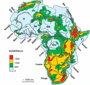
Africa is grouped into four relief regions: East, West, South and North.
| Region | Main relief | Examples |
|---|---|---|
| East | Mountains | Kilimanjaro, Kenya, Elgon, Rwenzori, Ethiopian Highlands |
| West | Highlands | Fouta Djallon, Guinea Highlands, Adamawa Highlands, Jos Plateau, Cameroon Mountain |
| South | Plateaux | Plateaux ending in the Great Escarpment, highest in the Drakensberg |
| North | Ranges | Ahaggar, Tassili, Tibesti, Darfur, Atlas Mountains |
East Africa
- Mount Kilimanjaro: 5,895 m, in Tanzania, the highest mountain in Africa.
- Mount Kenya: a high mountain in Kenya, the second highest in Africa.
- Mount Elgon: a mountain on the Kenya and Uganda border.
- Mount Rwenzori: a mountain range in the west of Uganda.
- Ethiopian Highlands: a large mountainous area in Ethiopia.
West Africa
- Fouta Djallon: a highland in Guinea.
- Guinea Highlands: highlands in the Guinea area, in the far west.
- Adamawa Highlands: highlands on the Nigeria and Cameroon border.
- Jos Plateau: a plateau in central Nigeria.
- Cameroon Mountain: a high mountain on the coast of Cameroon.
South Africa
- Plateaux: the region is mainly high plateau land.
- Great Escarpment: a continuous escarpment around the edge of the plateaux.
- Drakensberg Mountains: the highest part of the escarpment, in South Africa.
North Africa
- Atlas Mountains: a long range in the north-west of the continent.
- Ahaggar and Tassili: highlands in the Sahara.
- Tibesti: a mountain mass in the Sahara.
- Darfur: a highland area in western Sudan.
Where are the areas of lowland in Africa?
The lowlands of Africa are found mainly along the coasts and in river basins.
- Coasts: lowlands are found mainly along the coasts of Africa.
- River basins: the Congo Basin is a large low-lying area.
- Rift Valley: the floor of the East African Rift Valley is also low.
What is the East African Rift Valley system?
The Rift Valley is a long, narrow valley with steep walls, formed where a block of land sank between two faults.
Where is the Rift Valley?
- Extent: it stretches from the Red Sea to the Zambezi River area in Mozambique.
- Countries: it passes through Ethiopia, Kenya, Uganda, Tanzania, Malawi and Mozambique.
- Length: about 5,000 to 6,000 km.
How was the Rift Valley formed?
- Tension in the earth’s crust pulls the land apart.
- Cracks called faults form in the rock, running parallel to each other.
- The block of land between the two faults sinks. This is called subsidence.
- The raised land on each side is left as steep walls.
- The sunken floor becomes the rift valley, and lakes collect in parts of it.
What is the floor of the Rift Valley like?
- Floor: narrow and flat, with lakes.
- Depth: some parts lie below sea level.
- Walls: steep on both sides.
- Lake Tanganyika: the second deepest lake in the world.
- Lake Malawi: another large lake in the valley.
Why is the Rift Valley important?
- Tourism: the scenery, lakes and wildlife attract visitors.
- Fishing: the lakes supply fish.
- Salt mining: salts are obtained from some of the lakes.
- Rich agricultural land: the land in and around the valley is fertile.
What are the main rivers of Africa?
The four outstanding rivers of Africa are the Nile, Niger, Zambezi and Orange, chosen for their length and volume.
| River | Length | Where it flows |
|---|---|---|
| Nile | 6,600 km (longest) | North into the Mediterranean Sea |
| Niger | 4,200 km | Through Nigeria into the Gulf of Guinea |
| Zambezi | 2,400 km | East into the Indian Ocean |
| Orange | 1,600 km | West into the Atlantic Ocean |
River Nile
- Direction: flows north through Uganda, Sudan and Egypt into the Mediterranean Sea.
- Headstreams: the White Nile rises in the Lake Victoria area, and the Blue Nile rises in the Ethiopian Highlands.
- Dam: Lake Nasser is formed by the Aswan High Dam.
River Niger
- Source: rises in the Guinea Highlands in the far west.
- Tributary: the Benue joins it at Lokoja in Nigeria.
- Mouth: forms the Niger Delta before entering the Gulf of Guinea.
River Zambezi
- Direction: flows east into the Indian Ocean.
- Features: the Victoria Falls lie on it, and Lake Kariba is built on it.
River Orange
- Source: rises in the Drakensberg highlands.
- Direction: flows west across southern Africa into the Atlantic Ocean.
What are the main lakes of Africa?
Africa has two kinds of lake: natural lakes and artificial (man-made) lakes.
Natural lakes
- Lake Victoria: the largest lake in Africa, in East Africa.
- Lake Chad: a lake in the Sahel, shared by Nigeria and its neighbours.
- Lake Tanganyika: a deep lake in the Rift Valley.
- Lake Malawi: a lake in the Rift Valley.
- Lake Turkana: a lake in the Rift Valley in northern Kenya.
Artificial (man-made) lakes
An artificial lake is formed when a dam holds back the water of a river.
| Lake | River |
|---|---|
| Lake Nasser | Nile |
| Lake Volta | Volta |
| Lake Kainji | Niger |
| Lake Kariba | Zambezi |
- Lake Kariba: the largest man-made lake in Africa by volume.
- Lake Volta: the largest man-made lake in Africa by surface area.
- Uses: man-made lakes supply hydroelectric power, irrigation water and fish.
Evaluation
- Name the four relief regions of Africa.
- What is the highest mountain in Africa, and how high is it?
- Explain how the East African Rift Valley was formed.
- State four ways in which the Rift Valley system is important.
- Name the four outstanding rivers of Africa, starting with the longest.
Assignment
Draw an outline map of Africa and show and label these four rivers:
- River Nile
- River Niger
- River Orange
- River Zambezi
This term's Geography topics
SS2 Third Term · 8 topics
SS2 Geography Lesson Notes for Other Topics

Geographic Information System (GIS)
Read the full lesson note.
Location, Size, Position And Political Division Of Africa
Read the full lesson note.

Climate And Vegetation
Read the full lesson note.
Irrigation Agriculture In Nile Basin And The Niger Basin
Read the full lesson note.

Fruit Farming In The Mediterranean Regions Of Africa
Read the full lesson note.

Hydrosphere (Oceanic Basins)
Read the full lesson note.
Earthquakes
Read the full lesson note.

Action Of Running Water
Read the full lesson note.

Action Of Wind
Read the full lesson note.

Glacial Action
Read the full lesson note.
Action Of Wave
Read the full lesson note.

Climate & Climate Classification
Read the full lesson note.

Climate & Climate Classification II
Read the full lesson note.

Vegetation
Read the full lesson note.
Environmental Resources
Read the full lesson note.
Lesson Notes for Other Classes

SS1 Lesson Note
The complete lesson note to guide your studies.

SS3 Lesson Note
The complete lesson note to guide your studies.
