
Surveying And Planning Of Farmstead SS2 Agricultural Science Lesson Note
Download Lesson NoteTopic: Surveying And Planning Of Farmstead
MEANING OF FARM SURVEYING
Farm surveying is defined as the process of measuring and mapping out the position, topography, size and boundary of an area of farmland. It can also be defined as the process by which measuring land is made on the farm.
IMPORTANCE OF FARM SURVEYING
- It helps to determine the farmland.
- It is useful for the preparation of feasibility studies.
- It ensures proper use of the farmland.
- It helps in the proper location of the farm building.
- Farm maps or soil maps are useful in planning the farmstead.
- The results of a farm survey are used for soil classification.
- It can be used to project future yield.
- It can be used as collateral for a loan.
- It can be useful for the acquisition of C of O.
- It can be used to determine the gradient of the farmland.
SOME COMMON SURVEYING EQUIPMENT AND THEIR USES
-
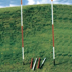
Ranging Pole/Rod
Description
- It is made up of wood or metal.
- It is of varying length e.g. 1.8, 2.4, 3m.
- It is usually painted black, bright red and white to enable it to be seen from a distance.
- It has a pointed end.
Functions
- It is useful for making stations.
- It is also used for making a straight line.
-
Gunter’s Chain
Description
- It consists of a series of dumbbell-shaped links of steel wire joined together by three small rings.
- The length is normally 20.13m (66ft). The chain is entirely metallic.
Function
- It is used to take a short detailed measurement of length and breadth.

Precautions When Chaining The Farmland
- Pull taut chains, tapes or ropes.
- Avoid errors in transporting figures on paper.
- All chains, tapes, ropes etc. must be properly aligned before taking the measurement.
- Avoid errors of parallax when reading measurements.
- Make sure the chain is not faulty before use.
-
Measuring Tape

Description
- It is usually made of linen or fine steel sheet.
- It is marked on one side with metric units and the other side with the empanel unit.
- The tape is normally wound in small ease from where it is unwound for use.
Function
- It is used for taking measurements of length, breadth and height.
-
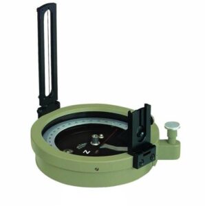
Prismatic Compass
Description
- It is normally placed on a stand.
- It has a prism.
- It has a compass card marked in degrees, half degrees, minutes and seconds, in a clockwise direction.
- It has a straight slot.
Function
- It is used in taking bearings. It is also used in the measurement of angular dista
-
Theodolite

Description
- It consists of a tripod stand, made of wood or lightweight metal in solid or telescope legs.
- The tripod stand forms the base of the instruments.
- It has a lower plate which contains the graduated horizontal circle made of glass or brass.
- It has a spirit level which is used to define horizontal planes against which angles of elevation or depression are measured.
Function
- It is used to measure horizontal or vertical angles or planes.
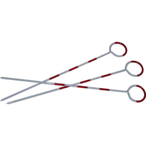
6) Arrow Or Pin
Description
- This is a thin pointed steel wire of about 30 cm long with one end curved into a ring.
- A red cloth is normally attached to the ring so that it can be seen from afar.
Function
- It is used during chaining for marking off-chain length as measured.
- It can also be used for making stations.
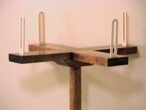
7) Offset Staff
Description
- This is a graduated rod 3m long.
- A hook may be fitted at the top to pull a chain through a hedge.
- Each telescopic link is 0.3m (30cm) in length.
Function
- It is used for taking short offset measurements.
8) Beacon Or Pillar
Description
- It is made of rectangular blocks usually in concrete form.
- Marks are usually inscribed on top of the block.
- The beacons are always burned in the ground with the marked head raised a little above ground.
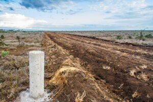
Function
- It is used for marking points off measured.
- It is also used for recognition of the measured or surveyed area.
GENERAL MAINTENANCE OF SURVEYING
- All instruments must be cleaned after use.
- Keep instruments in a dry and cool place.
- Metal parts should be oiled, greased or painted before storage.
- Keep them away from rain and heat to prevent rusting.
- Replace worn-out parts.
- Use the instruments only for the intended functions.
- Let competent surveyors handle and use the instruments only.
First Term Agricultural Science Lesson Notes for Other Topics

Preservation of Farm Produce
Explore lesson notes covering all topics.
Factors that may Hinder Preservation
Explore lesson notes covering all topics.
Methods of Preserving the Farm Produce; Sun Drying, Smoking
Explore lesson notes covering all topics.

Preservation of Grains and Cereals Crops
Explore lesson notes covering all topics.

Preservation of Roots and Tubers Crops
Explore lesson notes covering all topics.
Preservation of Fruits: Orange, Banana, Tomatoes, Pawpaw...
Explore lesson notes covering all topics.
Conservation of Oil Crops: Soya Bean, Oil Palm, Groundnut
Explore lesson notes covering all topics.
Preservation of Vegetables
Explore lesson notes covering all topics.

Health And Safety
Explore lesson notes covering all topics.

Procedures For Crop Production
Explore lesson notes covering all topics.
Crop Production
Explore lesson notes covering all topics.

Planting Activities
Explore lesson notes covering all topics.
Post-Planting Activities
Explore lesson notes covering all topics.

Post-Harvesting Activities; Sorting, Grading, And Storage
Explore lesson notes covering all topics.
Harvesting Activities
Explore lesson notes covering all topics.


Lesson Notes for Other Classes

Basic 1 Lesson Note
The complete lesson note to guide your studies.

Basic 2 Lesson Note
The complete lesson note to guide your studies.

Basic 3 Lesson Note
The complete lesson note to guide your studies.

Basic 4 Lesson Note
The complete lesson note to guide your studies.

Basic 5 Lesson Note
The complete lesson note to guide your studies.

Basic 6 Lesson Note
The complete lesson note to guide your studies.