
Nigeria: Location and Position – SS1 Geography Lesson Note (Second Term)
Lesson note at a glance
- Class
- SS1
- Subject
- Geography
- Term
- Second Term
- Reading time
- 5 min
Nigeria is a West African country that lies between latitudes 4°N and 14°N and longitudes 3°E and 15°E.
Behavioural objectives
- State the latitudinal and longitudinal location of Nigeria.
- Calculate the latitudinal and longitudinal extent of Nigeria.
- Name the countries and the ocean that border Nigeria.
- State the size and population of Nigeria.
- Name the colonial governors who ruled Nigeria before independence.
- Name the six geopolitical zones of Nigeria.
What key terms must I know?
- Location: the exact place of a country on the earth, given in degrees of latitude and longitude.
- Position: where a country lies in relation to the continent, the neighbours and the water around it.
- Latitude: an imaginary line drawn round the earth from east to west, measured in degrees north or south of the Equator.
- Longitude: an imaginary line drawn from the North Pole to the South Pole, measured in degrees east or west of the Greenwich Meridian.
- Equator: the line of latitude at 0°.
- Greenwich Meridian: the line of longitude at 0°, also called the Prime Meridian.
- Extent: the number of degrees a country covers from one edge to the opposite edge.
- Tropic of Cancer: the line of latitude at about 23½°N, which marks the northern limit of the tropics.
Where is Nigeria located?
Nigeria is located between latitudes 4°N and 14°N and between longitudes 3°E and 15°E.
- Latitude: between 4°N and 14°N of the Equator.
- Longitude: between 3°E and 15°E of the Greenwich Meridian.
- Continent: Africa.
- Region: West Africa.
- Climate belt: north of the Equator and south of the Tropic of Cancer, so Nigeria is in the tropics.
How do we calculate the extent of Nigeria?
The extent of Nigeria is found by subtracting the smaller limiting line from the larger one.
- Write down the two limiting latitudes: 4°N and 14°N.
- Subtract the smaller from the larger: 14° minus 4° = 10°. This is the latitudinal extent (south to north).
- Write down the two limiting longitudes: 3°E and 15°E.
- Subtract the smaller from the larger: 15° minus 3° = 12°. This is the longitudinal extent (west to east).
| Extent | Limits | Working | Answer |
|---|---|---|---|
| Latitudinal | 4°N to 14°N | 14° minus 4° | 10° |
| Longitudinal | 3°E to 15°E | 15° minus 3° | 12° |
What is the position of Nigeria?
The position of Nigeria is its place in West Africa, with the Atlantic Ocean to the south and four countries on its other sides.
- Place in Africa: Nigeria lies in West Africa.
- Southern edge: the coast faces the Atlantic Ocean, in the part called the Gulf of Guinea.
- Neighbours: four countries share land borders with Nigeria.
What is the difference between location and position?
- Location: the exact place of a country, given as numbers (degrees of latitude and longitude).
- Position: the place of a country described by its neighbours, continent and nearby water.
| Point | Location | Position |
|---|---|---|
| How it is stated | In degrees | In words |
| Example for Nigeria | 4°N to 14°N, 3°E to 15°E | West Africa, north of the Gulf of Guinea |
| Uses | Marking the country on a map grid | Showing neighbours, trade links and sea access |
Which countries and water body border Nigeria?
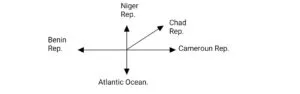
Nigeria is bordered by four countries (Niger, Chad, Cameroon and Benin) and the Atlantic Ocean.
| Neighbour | Direction from Nigeria |
|---|---|
| Niger Republic | North |
| Chad Republic | North-east |
| Cameroon Republic | East |
| Atlantic Ocean | South |
| Benin Republic | West |
- Francophone neighbours: Nigeria is surrounded by French-speaking (Francophone) countries, while English is Nigeria’s official language.
Why is the location of Nigeria useful?
The location of Nigeria gives it sea access, a tropical climate and land links with its neighbours.
- Access to the sea: the Atlantic coast allows ports and sea trade with other continents.
- Tropical climate: warm weather and rain support the growing of many crops.
- Land links: borders with four countries allow trade by road and rail.
- Standard time: Nigeria uses West African Time, which is one hour ahead of Greenwich Mean Time (GMT+1).
What is the size of Nigeria?
Nigeria has a land area of about 923,768 sq km and is the most populous country in Africa.
- Land area: about 923,768 sq km.
- West African rank: fourth largest in West Africa by land area, after Niger Republic, Mali and Mauritania.
- East to west: the greatest distance is about 1,300 km.
- North to south: the greatest distance is about 1,100 km.
- Population: over 140 million, according to the 2006 population census.
- Population rank: the most populous single country in Africa.
- Nickname: Nigeria is called the Giant of Africa because of this large population.
How is Nigeria divided politically?
Nigeria was formed in 1914 and is now divided into 36 states and the Federal Capital Territory.
- 1914: the Northern and Southern protectorates were amalgamated to form Nigeria.
- 1960: Nigeria became independent.
- Before independence: colonial governors ruled the country for Britain.
Who were the colonial governors of Nigeria?
Eight colonial governors ruled Nigeria for Britain, from Sir Frederick Lugard to Sir James Robertson.
| S/N | Name | Years ruled |
|---|---|---|
| 1 | Sir Frederick Lugard | 1912 to 1919 |
| 2 | Sir Hugh Clifford | 1919 to 1925 |
| 3 | Sir Graeme Thomson | 1925 to 1931 |
| 4 | Sir Donald Cameron | 1931 to 1935 |
| 5 | Sir Bernard Bourdillon | 1935 to 1943 |
| 6 | Sir Arthur Richards | 1943 to 1948 |
| 7 | Sir John Macpherson | 1948 to 1955 |
| 8 | Sir James Robertson | 1955 to 1960 |
What are the states and zones of Nigeria?
Nigeria has 36 states and the Federal Capital Territory, grouped into six geopolitical zones.
- Number of states: Nigeria is divided into 36 states and the Federal Capital Territory (FCT).
- Slogan: each state has a slogan or title that can be used to identify it.
- Capital of the country: Abuja, in the FCT.
- Geopolitical zones: North Central, North East, North West, South East, South South and South West.
| Zone | States |
|---|---|
| North Central | Benue, Kogi, Kwara, Nasarawa, Niger, Plateau (and the FCT) |
| North East | Adamawa, Bauchi, Borno, Gombe, Taraba, Yobe |
| North West | Jigawa, Kaduna, Kano, Katsina, Kebbi, Sokoto, Zamfara |
| South East | Abia, Anambra, Ebonyi, Enugu, Imo |
| South South | Akwa Ibom, Bayelsa, Cross River, Delta, Edo, Rivers |
| South West | Ekiti, Lagos, Ogun, Ondo, Osun, Oyo |

Evaluation
- Between which latitudes and longitudes is Nigeria located?
- Calculate the latitudinal and longitudinal extent of Nigeria.
- Name the countries and the ocean that border Nigeria.
- Why is Nigeria called the Giant of Africa?
- How many states does Nigeria have, and when did she become independent?
Assignment
List the colonial governors who ruled Nigeria between 1919 and 1943, with the years each one ruled.
This term's Geography topics
SS1 Second Term · 7 topics
SS1 Geography Lesson Notes for Other Topics
Physical Setting Of Nigeria: Relief And Drainage
Read the full lesson note.

The Nigerian Climate
Read the full lesson note.
Nigeria Vegetation
Read the full lesson note.
Nigerian Population
Read the full lesson note.
Nigeria Resources
Read the full lesson note.
Agriculture in Nigeria
Read the full lesson note.
Geography: An Introduction
Read the full lesson note.

The Earth's Rotation
Read the full lesson note.
The Earth's Revolution
Read the full lesson note.

Latitude & Longitude
Read the full lesson note.

The Earth's Structure
Read the full lesson note.
Rocks
Read the full lesson note.

Mountains
Read the full lesson note.
Lowlands
Read the full lesson note.
The Environment - Ecosystem & Its Component
Read the full lesson note.
Lesson Notes for Other Classes

SS2 Lesson Note
The complete lesson note to guide your studies.
SS3 Lesson Note
The complete lesson note to guide your studies.
