
Surveying and Planning of Farmstead – SS2 Agricultural Science Lesson Note (First Term)
Download this term · ₦1,000Lesson note at a glance
- Subject
- Agricultural Science
- Class
- SS2
- Term
- First Term
- Topic
- Surveying and Planning of Farmstead
- Order
- Topic 2 of 7 this term
- Reading time
- 7 min
Farm surveying is the process of measuring and mapping out the position, topography, size and boundary of an area of farmland.
- Use of results: they help in locating farm buildings, planning the farmstead and classifying soil.
- Equipment: surveyors use ranging poles, chains, tapes, compasses and theodolites.
Behavioural objectives
By the end of the lesson, students should be able to:
- define farm surveying and a farmstead;
- state the importance of farm surveying;
- describe common surveying equipment and state their uses;
- list the precautions to take when chaining farmland;
- state the factors to consider when planning a farmstead;
- state how surveying equipment should be maintained.
Why is farm surveying important?
Farm surveying is important because it gives the exact facts about a piece of land before it is developed.
- Boundary and size: it helps to determine the boundary and size of the farmland.
- Feasibility studies: it is useful for the preparation of feasibility studies.
- Land use: it ensures proper use of the farmland.
- Building location: it helps in the proper location of the farm buildings.
- Farmstead planning: farm maps or soil maps are useful in planning the farmstead.
- Soil classification: the results of a farm survey are used to classify soil.
- Yield projection: it can be used to project future yield.
- Collateral: the survey plan of the land can support an application for a loan.
- Land title: it is useful for the acquisition of a Certificate of Occupancy (C of O).
- Gradient: it can be used to determine the gradient (slope) of the farmland.
What equipment is used in farm surveying?
Farm surveying equipment is the set of tools used to measure distances, angles and heights and to mark points on the land.
| Equipment | Main use |
|---|---|
| Ranging pole | Marking stations and straight lines |
| Gunter’s chain | Measuring short, detailed lengths and breadths |
| Measuring tape | Measuring length, breadth and height |
| Prismatic compass | Taking bearings |
| Theodolite | Measuring horizontal or vertical angles |
| Arrow or pin | Marking each chain length |
| Offset staff | Taking short offset measurements |
| Beacon or pillar | Marking measured points permanently |
What is a ranging pole?
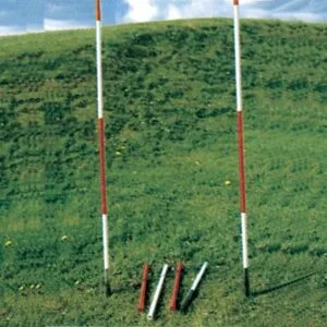
A ranging pole is a straight wooden or metal rod used to mark stations and straight lines.
Description
- Material: it is made of wood or metal.
- Length: it varies, for example 1.8 m, 2.4 m and 3 m.
- Colour: it is usually painted black, bright red and white so that it can be seen from a distance.
- Tip: it has a pointed end for pushing into the ground.
Functions
- Marking stations: it shows the points where measurements begin or end.
- Marking straight lines: it is used for marking out a straight line.
What is Gunter’s chain?
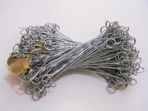
Gunter’s chain is a metal measuring chain, 20.12 m (66 ft) long, used to take short, detailed measurements.
Description
- Links: it consists of a series of dumbbell-shaped links of steel wire joined together by three small rings.
- Length: it is normally 20.12 m (66 ft).
- Material: the chain is entirely metallic.
Function
- Measuring: it is used to take short, detailed measurements of length and breadth.
What are the steps in chaining a line?
- Fix ranging poles at the two ends of the line.
- The leader takes the arrows and the forward end of the chain. The follower holds the other end at the starting station.
- The follower directs the leader until the chain lies along the line.
- Both pull the chain taut.
- The leader pushes an arrow into the ground at the end of the chain.
- Both move forward. The follower picks up the arrow when the chain reaches it.
- Repeat until the end of the line. Record the number of arrows and the remaining length.
What precautions should be taken when chaining farmland?
- Tension: pull chains, tapes and ropes taut.
- Recording: avoid errors when recording figures on paper.
- Alignment: align all chains, tapes and ropes properly before taking the measurement.
- Reading: avoid errors of parallax when reading measurements.
- Condition: make sure the chain is not faulty before use.
What is a measuring tape?
A measuring tape is a flexible strip, marked in units of length, used to measure length, breadth and height.

Description
- Material: it is usually made of linen or fine steel sheet.
- Markings: one side carries metric units and the other side carries imperial units.
- Case: the tape is normally wound in a small case, from which it is unwound for use.
Function
- Measuring: it is used for taking measurements of length, breadth and height.
What is a prismatic compass?
A prismatic compass is an instrument used to take bearings and measure angular distance.
Description
- Stand: it is normally placed on a stand.
- Prism: it has a prism through which the reading is taken.
- Compass card: it is marked in degrees, half degrees, minutes and seconds, in a clockwise direction.
- Slot: it has a straight slot for sighting.

Function
- Bearings: it is used for taking bearings and for measuring angular distance.
What is a theodolite?
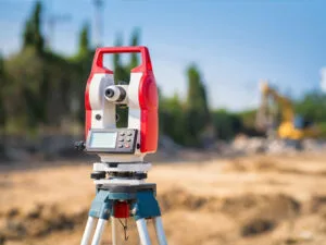
A theodolite is a surveying instrument on a tripod stand, used to measure horizontal or vertical angles.
Description
- Tripod stand: it is made of wood or lightweight metal, with solid or telescopic legs.
- Base: the tripod stand forms the base of the instrument.
- Lower plate: it contains the graduated horizontal circle made of glass or brass.
- Spirit level: it is used to define horizontal planes against which angles of elevation or depression are measured.
Function
- Angles: it is used to measure horizontal or vertical angles or planes.
What is an arrow or pin?
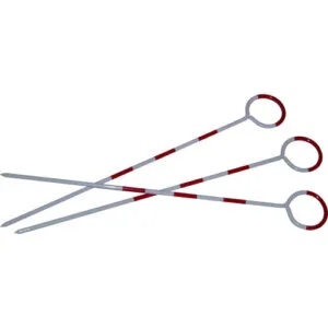
An arrow, or pin, is a thin steel marker pushed into the ground to mark each chain length.
Description
- Shape: it is a thin, pointed steel wire about 30 cm long, with one end curved into a ring.
- Red cloth: it is normally attached to the ring so that the arrow can be seen from afar.
Functions
- Marking chain lengths: it is used during chaining to mark off each chain length as measured.
- Marking stations: it can also be used for marking stations.
What is an offset staff?
An offset staff is a graduated rod used to take short offset measurements.
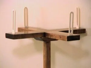
Description
- Length: it is a graduated rod 3 m long.
- Hook: a hook may be fitted at the top to pull a chain through a hedge.
- Links: each telescopic link is 0.3 m (30 cm) in length.
Function
- Offsets: it is used for taking short offset measurements.
What is a beacon or pillar?
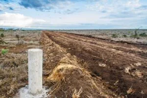
A beacon, or pillar, is a concrete block buried in the ground to mark a measured point permanently.
Description
- Material: it is made of rectangular blocks, usually of concrete.
- Marks: marks are usually inscribed on top of the block.
- Position: beacons are buried in the ground with the marked head raised a little above ground level.
Functions
- Marking points: it is used for marking measured points.
- Recognition: it is also used for recognition of the measured or surveyed area.
What is a farmstead?
A farmstead is the area of a farm that holds the farm buildings and the farmer’s house, with the yards and paths around them.
- Farm house: the home of the farmer or manager.
- Animal houses: pens, poultry houses and fish ponds.
- Store and barns: places for produce, feed, tools and machines.
- Yards and paths: open spaces and tracks that link the buildings.
What factors are considered when planning a farmstead?
Planning a farmstead means deciding where each building should stand, using the results of the farm survey and the farm map.
- Water supply: the farmstead should be near a reliable source of water.
- Access road: good roads help the movement of inputs, produce and workers.
- Drainage and slope: the site should be well drained and not liable to flooding.
- Soil: buildings should not stand on the best crop land.
- Nearness to market: a short distance to the market reduces transport cost and produce loss.
- Wind direction: animal houses should be placed so that smell and dust do not blow towards the farm house.
- Security: the buildings should be placed where the farmer can supervise them easily.
- Services: electricity and labour should be available.
- Room for expansion: space should be left for future buildings.
- Land title: the land should have clear ownership and boundaries.
How should surveying equipment be maintained?
Maintenance means caring for surveying instruments so that they stay accurate and last long.
- Cleaning: clean all instruments after use.
- Storage: keep instruments in a dry and cool place.
- Protection of metal parts: oil, grease or paint metal parts before storage.
- Rust prevention: keep instruments away from rain and heat.
- Repairs: replace worn-out parts.
- Correct use: use the instruments only for their intended functions.
- Handling: allow only competent surveyors to handle and use the instruments.
Evaluation
- Define farm surveying.
- State five reasons why farm surveying is important.
- List four precautions to take when chaining farmland.
- Name the instrument used for taking bearings and the one used for measuring horizontal or vertical angles.
- State four factors to consider when planning a farmstead.
Assignment
Describe the ranging pole and the beacon, and state two functions of each.
This term's Agricultural Science topics
SS2 First Term · 7 topics
Get Agricultural Science as PDF and Word
Every week of SS2 Agricultural Science, First Term, formatted and ready to print. Ad-free, and the copy lock comes off.
Get this term Card, bank transfer, USSD or OPay
SS2 Agricultural Science Lesson Notes for Other Topics

Environmental Physiology
Read the full lesson note.
Irrigation And Drainage
Read the full lesson note.

Factors Affecting Nutrient Availability In The Soil
Read the full lesson note.

Environmental Factors Affecting Agricultural Productivity And Distribution
Read the full lesson note.

Plant Nutrient And Nutrient Cycle
Read the full lesson note.

Surveying And Planning Of Farmstead II
Read the full lesson note.

Forest Management
Read the full lesson note.

Floriculture And Ornamental Plants
Read the full lesson note.

Diseases In Crops
Read the full lesson note.

General Effects Of Diseases On Crop Production
Read the full lesson note.
Pest Of Crops
Read the full lesson note.
Pasture, Forage Crops And Range Management
Read the full lesson note.

Common Weeds Found On The Farm
Read the full lesson note.

Crop Improvement
Read the full lesson note.

Basic Economic Principles - Law of Demand, Supply & Diminishing Returns
Read the full lesson note.
Lesson Notes for Other Classes

SS1 Lesson Note
The complete lesson note to guide your studies.
SS3 Lesson Note
The complete lesson note to guide your studies.
