
Satellite Remote Sensing – SS3 Geography Lesson Note (First Term)
Lesson note at a glance
- Class
- SS3
- Subject
- Geography
- Term
- First Term
- Reading time
- 5 min
Satellite remote sensing is the collection of information about the Earth from a distance, without direct contact, using sensors carried on satellites.
Behavioural objectives
By the end of the lesson, students should be able to:
- Explain the concept of remote sensing.
- Name the two types of remote sensing and give one example of each.
- Describe the steps by which a satellite collects and delivers data.
- Discuss the relationship between remote sensing and GIS.
- Examine applications of satellite remote sensing, with Nigerian examples.
- State the advantages and limitations of satellite remote sensing.
Instructional techniques
- Identification
- Explanation
- Questions and answers
- Demonstration
- Videos on satellite imagery
Instructional materials
- Videos
- Loudspeaker
- Textbook
- Pictures and printed satellite images
What is remote sensing?
Remote sensing is the technology of capturing information about objects or areas from a distance, without direct contact.
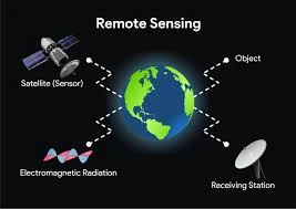
- Sensor: an instrument that detects and records energy coming from the Earth’s surface.
- Platform: the carrier of the sensor, such as a satellite, an aircraft or a drone.
- Electromagnetic spectrum: the range of energy waves, including visible light and infrared, that sensors record.
- Imagery: the pictures produced from the data a sensor collects.
- Fields of use: environmental monitoring, agriculture, geology and urban planning.
What are the platforms used in remote sensing?
There are three common platforms: ground-based, airborne and spaceborne.
- Ground-based: sensors on towers, vehicles or hand-held devices close to the surface.
- Airborne: sensors on aircraft, balloons or drones, giving detailed images of small areas.
- Spaceborne: sensors on satellites, giving repeated views of very large areas.
What are the types of remote sensing?
There are two types of remote sensing: passive and active.
Passive remote sensing
- Meaning: the sensor records natural energy, mostly sunlight reflected from the Earth.
- Example: a satellite camera taking pictures of farmland in daylight.
Active remote sensing
- Meaning: the sensor sends out its own energy and records what bounces back.
- Example: radar, which can work at night and through cloud.
| Feature | Passive | Active |
|---|---|---|
| Energy source | The Sun | The sensor itself |
| Works at night | Optical sensors do not | Yes |
| Affected by cloud | Yes, for optical sensors | Radar can see through cloud |
How does satellite remote sensing work?
A satellite collects data by recording energy from the Earth and sending it to a ground station.
- An energy source, usually the Sun, sends energy towards the Earth.
- The energy passes through the atmosphere.
- The energy strikes the surface, such as water, soil, vegetation or buildings.
- Each surface reflects or gives off energy in its own way.
- The satellite sensor records this energy.
- The data are sent to a ground station.
- The data are processed into images and analysed, often in a GIS.
What is the relationship between remote sensing and GIS?
GIS (Geographic Information System) is a computer system that stores, analyses and displays spatial data. Remote sensing supplies much of the data that a GIS uses.
| Area | Remote sensing | GIS |
|---|---|---|
| Data integration | Collects data from a distance using sensors on satellites or aircraft, producing imagery and information about the Earth’s surface. | Uses spatial data, including maps and imagery, to analyse relationships between different geographical features. |
| Spatial information | Provides spatial data in the form of images, which can include visible light, infrared and other spectral bands. | Organises, stores and analyses spatial data to create maps and answer spatial queries. |
| Data analysis | Offers raw data that can be processed to extract information about land cover, vegetation health and environmental change. | Combines remote sensing data with other datasets, allowing analysis and the overlaying of different layers. |
| Mapping and visualisation | Produces imagery that shows the Earth’s surface, so features and changes can be identified. | Uses remote sensing data as map layers to show spatial patterns and relationships. |
| Environmental monitoring | Captures current or past data on land cover change, deforestation and natural disasters. | Analyses the data to monitor and model environmental trends for sustainable resource management. |
What are the applications of satellite remote sensing?
Satellite remote sensing has ten main applications.
- Environmental monitoring: tracks land cover change and deforestation over time, for example desert advance in northern Nigeria.
- Agriculture: assesses crop health, checks soil conditions and guides irrigation.
- Weather forecasting: satellite observations help predict and monitor weather patterns and give timely warnings.
- Disaster management: maps floods, storms and fires, and shows damage after disasters such as earthquakes, to guide relief. River flooding along the Niger and Benue is an example.
- Urban planning: monitors urban growth, plans infrastructure and shows changes in built-up areas, as in Lagos and Abuja.
- Natural resource management: monitors water, minerals and forests.
- Climate change studies: tracks climate indicators, ice caps and sea levels.
- Telecommunications: communication satellites relay signals to remote areas. These are different from the satellites that observe the Earth.
- Military and defence: satellite imagery supports reconnaissance, surveillance and monitoring of military activity.
- Scientific research: satellite data support geology, climatology and astronomy.
What are the advantages and limitations of satellite remote sensing?
Satellite remote sensing gives wide, repeated coverage, but it has some limits.
Advantages
- Wide coverage: one image can show a very large area.
- Access to remote places: it records areas that are dangerous or hard to reach, such as swamps and forests.
- Repeated observation: the same place can be imaged again and again to show change.
- Saves time and cost: it reduces the need for long field surveys.
Limitations
- Cloud cover: optical sensors cannot see through thick cloud.
- High cost: building, launching and running satellites is expensive.
- Skill needed: trained people are required to process and interpret the images.
- Ground checks: results often need confirming by fieldwork.
Evaluation
- What is remote sensing?
- Name the two types of remote sensing and state one difference between them.
- Discuss the relationship between remote sensing and GIS. Give four points.
- Mention five applications of satellite remote sensing.
- State two limitations of satellite remote sensing.
Assignment
Choose one application of satellite remote sensing. Explain in one page how it helps your state or region, and state how a GIS would use the data.
This term's Geography topics
SS3 First Term · 10 topics
SS3 Geography Lesson Notes for Other Topics
Volcanicity
Read the full lesson note.
Karst (Limestone) Topography
Read the full lesson note.
Denudational Processes
Read the full lesson note.
Weathering
Read the full lesson note.
Mass Movements
Read the full lesson note.
Climatic Change
Read the full lesson note.
ECOWAS
Read the full lesson note.

World Trade
Read the full lesson note.

Tourism
Read the full lesson note.

GIS Application
Read the full lesson note.

Bush Fallowing in West Africa
Read the full lesson note.

Mining in Africa (Copper, Gold, and Petroleum)
Read the full lesson note.
Principle of Elementary Surveying
Read the full lesson note.
Representation of Relief Form
Read the full lesson note.
Map Readings
Read the full lesson note.
Lesson Notes for Other Classes
SS1 Lesson Note
The complete lesson note to guide your studies.

SS2 Lesson Note
The complete lesson note to guide your studies.
