
Principle of Elementary Surveying – SS3 Geography Lesson Note (Second Term)
Lesson note at a glance
- Class
- SS3
- Subject
- Geography
- Term
- Second Term
- Reading time
- 6 min
Surveying is the measurement of the Earth’s surface to find the position, shape, distances, angles and heights of features on the land.
Behavioural objectives
By the end of the lesson, students should be able to:
- Define surveying and explain common surveying terms.
- Describe the main surveying instruments.
- State the uses of the chain and the prismatic compass in surveying.
- List the procedures for plotting a traverse.
- Discuss ways of avoiding and overcoming obstacles in the field.
What is surveying used for?
Surveying is used to produce accurate maps, plans and measurements of land for planning and building.
- Construction: setting out buildings, roads, bridges and drains on the ground.
- Mapping: producing maps and plans that show terrain and features.
- Land development: dividing land into plots and marking boundaries.
- Planning: supplying measurements for water supply, drainage and farm layout.
What are the common terms used in surveying?
Surveying terms are the words used to describe points, lines, directions and measurements in a survey.
- Station: a point on the ground where a survey line starts, ends or changes direction.
- Baseline: the main measured line from which other survey lines are fixed.
- Traverse: a series of connected survey lines whose lengths and directions are measured.
- Bearing: the horizontal angle between a survey line and north, measured clockwise.
- Offset: a short measurement taken at right angles from a survey line to a feature.
- Scale: the ratio between a distance on the map and the same distance on the ground.
- Benchmark: a point with a precisely known elevation, used as a reference for other heights.
What are the instruments used in surveying?
Surveying instruments are the tools used to measure distances, angles, directions and heights.
- Total station: measures angles and distances electronically, combining a theodolite and an electronic distance meter.
- Theodolite: an optical instrument for measuring horizontal and vertical angles.
- Level: finds height differences between points on the ground.
- Auto level: a level that keeps its line of sight horizontal automatically once it is roughly levelled.
- GPS (Global Positioning System): a satellite-based system that gives the position of a point on the Earth’s surface.
- Chain: a series of connected metal links used to measure distances on the ground.
- Measuring tape: a flexible tape, usually steel or fibreglass, for measuring shorter distances.
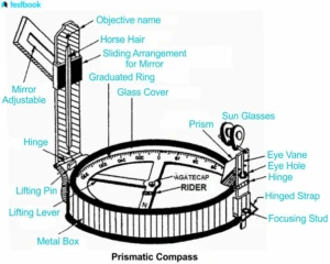
- Prismatic compass: measures the magnetic bearing of a survey line.
- Prism and prism pole: the prism reflects the signal back to a total station, and the pole holds it at a known height.
- Ranging pole: a straight pole, usually painted in bands, used to mark stations and keep survey lines straight.
- Arrows: metal pins pushed into the ground to mark the end of each chain length.
What are the uses of the chain and the prismatic compass in surveying?
The chain measures distances on the ground, and the prismatic compass measures directions.
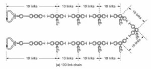
What are the uses of the chain?
- Measuring distance: the chain is stretched between two points to find the distance between them.
- Measuring survey lines: it gives the lengths of the lines in a traverse.
- Measuring offsets: it is used with ranging poles and arrows to fix the position of features along a line.
- Common lengths: metric chains are usually 20 m or 30 m long. A 20 m chain has 100 links.
What are the uses of the prismatic compass?
- Measuring bearings: it gives the magnetic bearing of a line, which is its angle from magnetic north.
- Fixing direction: surveyors use it to set a reference direction for the survey.
- Traversing: the bearing of each survey line is read and recorded for plotting later.
- Precaution: iron, steel and power lines near the compass can change the reading.
What is a traverse?
A traverse is a series of connected survey lines whose lengths and directions are measured.
- Closed traverse: the last line ends at the starting station, so the lines form a closed figure.
- Open traverse: the last line ends at a different point from the start, as in a road or pipeline survey.
What are the procedures for plotting a traverse?
Plotting a traverse means drawing the measured survey lines and angles to scale on paper.
- Select a scale: choose a scale that fits the survey on the drawing sheet.
- Draw a baseline: draw one measured survey line first, for example along the bottom of the sheet.
- Plot angles: use a protractor to draw the measured angle or bearing of the next line.
- Plot distances: use the scale to mark each line length along its direction.
- Complete the traverse: repeat the angles and distances until every line is drawn.
- Check closure: in a closed traverse, the last line must end at the starting station.
- Adjust errors: if there is a gap, it is the closing error, and the measurements or plotting must be checked.
- Label points: name each station where survey lines meet.
What are the ways of avoiding obstacles in the field?
Obstacles in the field are avoided by planning ahead with site visits, maps, images and safety rules.
- Pre-survey site visit: visit the site first to identify buildings, trees, ponds or other structures.
- Aerial imagery: study satellite images or aerial photographs of the terrain.
- Talk to landowners: ask landowners or property managers about obstacles on the site.
- GPS and GIS: map the survey area and plan the survey lines around known obstacles.
- Remote sensing tools: use tools such as LiDAR or ground-penetrating radar to detect hidden obstacles and surface features.
- Safety protocols: set safety rules and contingency plans, and carry safety equipment.
How are obstacles overcome when chaining a line?
Obstacles to chaining are overcome by running a temporary line around them and measuring along it.
| Type of obstacle | Example | Method |
|---|---|---|
| Obstacle to chaining only | Pond or river | Set out equal offsets at right angles from two points on the line. Measure the line joining their ends. This equals the blocked distance. |
| Obstacle to ranging only | Hill or thick bush | Use reciprocal ranging. Two surveyors with poles on either side of the rise guide each other onto the line. |
| Obstacle to both | Building | Set out equal offsets to one side. Run a parallel line past the building. Return to the main line with equal offsets. Measure the parallel line. |
Evaluation
- What is surveying?
- Mention five common instruments used for surveying.
- Mention five ways of avoiding obstacles in the field.
- Identify two uses of the prismatic compass in surveying.
- What is a closing error in a traverse?
Assignment
List the procedures for plotting a traverse and state two uses of the chain in surveying.
This term's Geography topics
SS3 Second Term · 6 topics
- GIS Application
- Bush Fallowing in West Africa
- Mining in Africa (Copper, Gold, and Petroleum)
- Principle of Elementary Surveying
- Representation of Relief Form
- Map Readings
SS3 Geography Lesson Notes for Other Topics

GIS Application
Read the full lesson note.

Bush Fallowing in West Africa
Read the full lesson note.

Mining in Africa (Copper, Gold, and Petroleum)
Read the full lesson note.
Representation of Relief Form
Read the full lesson note.
Map Readings
Read the full lesson note.
Volcanicity
Read the full lesson note.
Karst (Limestone) Topography
Read the full lesson note.
Denudational Processes
Read the full lesson note.
Weathering
Read the full lesson note.
Mass Movements
Read the full lesson note.
Climatic Change
Read the full lesson note.
ECOWAS
Read the full lesson note.

World Trade
Read the full lesson note.

Tourism
Read the full lesson note.

Satellite Remote Sensing
Read the full lesson note.
Lesson Notes for Other Classes

SS1 Lesson Note
The complete lesson note to guide your studies.
SS2 Lesson Note
The complete lesson note to guide your studies.
