
The Early Regions in Nigeria – Basic 4 History Lesson Note (First Term)
Download this term · ₦1,000Lesson note at a glance
- Subject
- History
- Class
- Basic 4
- Term
- First Term
- Topic
- The Early Regions in Nigeria
- Order
- Topic 2 of 6 this term
- Reading time
- 4 min
The early regions of Nigeria were the large areas into which the British colonial government divided the country so that it could be ruled more easily.
Behavioural objectives
- Define the word “region”.
- Name the three early regions of Nigeria and state the capital of each.
- Identify the main people and the main religion of each early region.
- State four reasons why the regions were created.
- Locate the early regions on a map of Nigeria.
What is a region?
A region is a large area of land with its own features that set it apart from other areas.
- People and culture: the people in it are similar in culture.
- Government: it is ruled under one type of government.
- Language and traditions: the people share a language or traditions.
- Boundaries: clear borders separate it from other areas.
- Example: dividing Nigeria into big sections makes it easier to manage.
What were the early regions in Nigeria?
There were three early regions in Nigeria: the Northern Region, the Western Region and the Eastern Region.
| Region | Capital | Main people | Main religion |
|---|---|---|---|
| Northern | Kaduna | Hausa-Fulani | Islam |
| Western | Ibadan | Yoruba | Christianity, Islam and traditional religion |
| Eastern | Enugu | Igbo | Christianity and traditional religion |
What was the Northern Region?
The Northern Region was the large region covering the northern part of Nigeria.
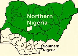
- Created: 1900, as the Northern Protectorate.
- Created by: the British Colonial Government.
- Capital: Kaduna.
- Covered: the northern parts of Nigeria.
- Main people: Hausa-Fulani.
- Main religion: Islam.
What was the Southern Region?
The Southern Region was the southern part of Nigeria, which the British later divided into two.
- Created: 1900, as the Southern Protectorate.
- Created by: the British Colonial Government.
- Later divided into: the Western and Eastern parts of the south.
What was the Western Region?
The Western Region was the south-western part of Nigeria, home mainly to the Yoruba.
- Created: 1939, when the south was divided in two.
- Created by: the British Colonial Government.
- Capital: Ibadan.
- Main people: Yoruba.
- Main religion: Christianity, Islam and traditional religion.
What was the Eastern Region?
The Eastern Region was the south-eastern part of Nigeria, home mainly to the Igbo.
- Created: 1939, when the south was divided in two.
- Created by: the British Colonial Government.
- Capital: Enugu.
- Main people: Igbo.
- Main religion: Christianity and traditional religion.
How did the early regions develop?
The regions developed in steps between 1900 and 1960.
- 1900: the British set up the Northern and Southern protectorates.
- 1914: Lord Lugard joined the North and the South into one country, Nigeria. He became Governor-General.
- 1939: the south was divided into the Western and Eastern parts.
- 1946: a new constitution set up three regions: Northern, Western and Eastern.
- 1960: Nigeria became independent.
Why were the regions created?
The regions were created for five main reasons: easier administration, cultural differences, economic reasons, better control and geographic differences.
Easier administration
- Size: Nigeria was too big for one person to manage.
- Governors: different officials could handle each region.
- Decisions: decisions were faster in smaller areas.
Cultural differences
- Ethnic groups: different groups lived in different areas.
- Languages and customs: these differed from area to area.
- Religion: Islam was mainly in the North and Christianity mainly in the South.
Economic reasons
- North: cotton, groundnuts and livestock.
- West: cocoa and palm oil.
- East: coal, palm oil and yam.
Better control
- Divide and rule: this was a British strategy for ruling.
- Unity: it made it harder for Nigerians to act together.
- Smaller groups: these were easier to control.
Geographic differences
- North: mostly savanna and semi-desert.
- South: mostly forest and coastal areas.
- Lifestyle: farming and ways of living differed with the land.
Where were the early regions located?
The Northern Region lay in the north, the Western Region in the south-west and the Eastern Region in the south-east.
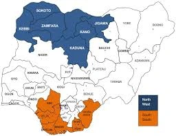
Where was the Northern Region?
- Covered: the area mainly north of the Rivers Niger and Benue.
- States today: Sokoto, Kano, Kaduna, Bauchi, Borno and others.
- Size: the largest region by land area.
Where was the Western Region?
- Covered: the south-west of Nigeria.
- States today: Lagos, Ogun, Oyo, Osun, Ondo and Ekiti.
- Border: the Atlantic Ocean to the south.
Where was the Eastern Region?
- Covered: the south-east and parts of the South-South.
- States today: Enugu, Anambra, Imo, Abia, Ebonyi and Cross River.
- Border: Cameroon to the east.
Evaluation
- What is a region?
- Match each region with its capital: Northern, Western, Eastern (Ibadan, Enugu, Kaduna).
- State four reasons why the regions were created.
- Put these in order: independence, Northern and Southern protectorates set up, Western and Eastern parts of the south created, Lugard became Governor-General.
- Which early region does each state belong to: Lagos, Kano, Enugu? Which region was the largest by area?
Answer key
- A large area of land with similar people, the same type of government and clear boundaries.
- Northern: Kaduna. Western: Ibadan. Eastern: Enugu.
- Any four of: easier administration, cultural differences, economic reasons, better control, geographic differences.
- Northern and Southern protectorates (1900), Lugard became Governor-General (1914), Western and Eastern parts created (1939), independence (1960).
- Lagos: Western. Kano: Northern. Enugu: Eastern. The largest was the Northern Region.
Assignment
Draw a simple map of Nigeria. Mark and label the Northern, Western and Eastern regions, and write the capital of each.
This term's History topics
Basic 4 First Term · 6 topics
Get History as PDF and Word
Every week of Basic 4 History, First Term, formatted and ready to print. Ad-free, and the copy lock comes off.
Get this term Card, bank transfer, USSD or OPay
Basic 4 History Lesson Notes for Other Topics
Colonial Administration in Nigeria
Read the full lesson note.
Ethnic Groups in the Four Early Regions in Nigeria
Read the full lesson note.

British Protectorate Administrative Headquarters
Read the full lesson note.

Colonial Administrative Headquarters in Nigeria (Continued)
Read the full lesson note.
State Creation in Nigeria 1967
Read the full lesson note.
State Creation in Nigeria 1976 Till Date
Read the full lesson note.
Federal Capital
Read the full lesson note.
Federal Capital II
Read the full lesson note.

Heroes in Nigeria Environment
Read the full lesson note.
Heroines in Nigeria
Read the full lesson note.

Some Nigerian Peoples - Northern Nigeria
Read the full lesson note.

Some Nigerian Peoples - Southern Nigeria
Read the full lesson note.
Important Historical Features and Sites in Southern Nigeria
Read the full lesson note.
Lesson Notes for Other Classes
Basic 1 Lesson Note
The complete lesson note to guide your studies.

Basic 2 Lesson Note
The complete lesson note to guide your studies.

Basic 3 Lesson Note
The complete lesson note to guide your studies.

Basic 5 Lesson Note
The complete lesson note to guide your studies.
Basic 6 Lesson Note
The complete lesson note to guide your studies.
