
Land and the People of Nigeria – SS1 Nigerian History Lesson Note (First Term)
Download this term · ₦1,000Lesson note at a glance
- Subject
- Nigerian History
- Class
- SS1
- Term
- First Term
- Topic
- Land and the People of Nigeria
- Order
- Topic 4 of 11 this term
- Reading time
- 5 min
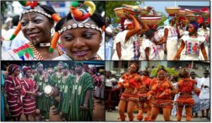
Nigeria is a country of many peoples and four geographical zones: coastal, forest, semi-savannah and savannah. The political entity named Nigeria was created by the British in 1914, but the land and its peoples existed long before then. Geography shaped how people earned a living and travelled, and each major group has its own tradition of origin.
Behavioural objectives
By the end of the lesson, students should be able to:
- state when and by whom the political entity named Nigeria was created;
- name the main peoples of Nigeria and the largest groups;
- describe the four geographical zones of Nigeria;
- explain how geography affected the occupations and transport of the people;
- outline the traditions of origin of the Yoruba, Edo, Kanuri, Hausa and Igbo.
What was Nigeria like before 1914?
There was no political entity named Nigeria before 1914. However, the landmass and the various ethnic groups were in existence from the earliest times, and there was mutual interaction between the ethnic groups. The British took advantage of the interaction between the peoples around the rivers Niger and Benue to create a political entity named Nigeria in 1914.
The history of Nigeria before 1800 was that of city-states, kingdoms and clannish units. Their political structure was made up of the King, Chiefs, Warriors and Subjects.
Who are the peoples of Nigeria?
Nigeria, with about 200 million people, has the largest black population of any country in the world. It is also the richest country of tropical Africa, with a Gross National Product of about 61 billion Naira. There are many different peoples, such as the Yoruba, Igbo, Ijaw, Hausa, Fulani, Nupe and Jukun. The largest of these groups are the Hausa and Fulani in the North, the Yoruba in the Southwest and the Igbo in the Southeast. English is our official language.
Nigeria measures about 1,000 kilometres from north to south and over 1,200 kilometres from west to east. There are great regional variations within it, and these can be divided into four zones: the coastal, forest, semi-savannah and savannah.
What are the geographical zones of Nigeria?
The geography of any country means its physical features, which affect human activity and the distribution of population and resources. There are four main geographical zones in Nigeria:
- Coastal region: This is a long piece of lowland from Lagos in the west to Calabar in the east. It is characterised by features such as lagoons, creeks and the Niger Delta.
- Forest region: There is heavy rainfall in this region, and this results in thick vegetation. Big trees like iroko, obeche and walnut can be found in the forest zone. It is mostly the southern part of Nigeria, which includes Oyo, Ogun, Ondo, Kwara, Ekiti, Cross River, Enugu, Imo and Abia.
- Semi-savannah: This zone is an area between the forest region and the savannah. There are trees and tall grasses in this zone, and the rainfall is lighter than in the forest zone.
- Savannah: This zone has open woodlands and grasslands. Movement, especially for horses, has always been easier here than in the forest region. The crops which grow in the savannah are also different from those that grow in the forest zone.
How does geography affect people’s activities?
The effect of geography on the people of Nigeria is enormous.
Occupations and products
- Lagoon shores and sea coast: Fishing and the exploitation of the coconut palm provided the basis of the livelihood of the inhabitants.
- Mangrove swamps in the Niger Delta: The people there fish and pan salt from the saltwater creeks. They supplied the salt in exchange for agricultural produce and iron tools from the hinterland.
- Forest zone: The lack of grazing and the prevalence of the tsetse fly made it difficult to keep horses and cattle. Movement was also more difficult than in the open savannah.
Movement and means of transportation
- In the coastal region, people travel on boats and canoes along the rivers, creeks, lagoons and delta.
- People in the forest region move on footpaths.
- People in the savannah travelled on horses and donkeys.
What are the traditions of origin of Nigerian peoples?
The traditions of origin of the different Nigerian peoples rest on oral tradition, legend, myth and folktales. Most of them claim that the people migrated from the Middle East. The traditions of the main groups are as follows.
The Yoruba
The creation tradition claims that God sent Oduduwa down from heaven through a rope to the earth. The place where he landed was named Ile-Ife, and from there life started. The migration legend states that the Yoruba people, under the leadership of Oduduwa, migrated from Mecca to Ile-Ife, where they began to spread over Yorubaland.
The Edo
According to oral tradition, the Edo people came from Egypt. They migrated through North Africa to Western Sudan and moved further southwards until they founded Benin between 800 and 900 A.D.
The Kanuri
The Kanuri originated from the Arab and Berber peoples of North Africa. They migrated southwards to the zone around Lake Chad and absorbed the native people. They established the Kanembu empire and instituted the Sefawa dynasty. The second Kanuri empire was founded on the western side of Lake Chad.
The Hausa
The Hausa originated from Bayajida, who came from the royal house of Baghdad. Bayajida and his entourage moved to Borno, stayed for some time and later arrived in Daura in Hausaland. Bayajida killed a snake in Daura and married the queen, who bore him a son, Bawo. Bawo in turn gave birth to seven sons, who established the seven legitimate Hausa states and the seven illegitimate Hausa states.
The Igbo
The Igbo migrated from the Jews in the Middle East and moved southwards through North Africa to Western Sudan. They settled first in the place called Awka, from where they spread over the eastern part of Nigeria.
Evaluation
- In what year, and by whom, was the political entity named Nigeria created?
- Name the four geographical zones of Nigeria.
- State two ways in which geography affected the occupations of people in the Niger Delta and the forest zone.
- Describe the creation tradition of the Yoruba.
- Who was Bayajida, and what did he do in Daura?
Assignment
- Draw the map of Nigeria, highlighting the geographical zones.
This term's Nigerian History topics
SS1 First Term · 11 topics
Get Nigerian History as PDF and Word
Every week of SS1 Nigerian History, First Term, formatted and ready to print. Ad-free, and the copy lock comes off.
Get this term Card, bank transfer, USSD or OPay
SS1 Nigerian History Lesson Notes for Other Topics

Introduction To History
Read the full lesson note.

Historical Skills
Read the full lesson note.
Prospect of ICT In Historical Studies
Read the full lesson note.
Traditions Of Origin Of Various Groups
Read the full lesson note.
Centers Of Ancient Civilization
Read the full lesson note.

The State Formation Process
Read the full lesson note.

Genres/Branches Of Literature
Read the full lesson note.

Prose: Literary And Non-Literary
Read the full lesson note.

Poetry
Read the full lesson note.

Drama
Read the full lesson note.

CENTRALIZED STATES KANEM - BORNU UP TO 1800
Read the full lesson note.

THE HAUSA STATE UP TO 1800
Read the full lesson note.

NUPE UP TO 1800
Read the full lesson note.

IGALA UP TO 1800
Read the full lesson note.

THE JUKUN KINGDOM
Read the full lesson note.
Lesson Notes for Other Classes

SS2 Lesson Note
The complete lesson note to guide your studies.

SS3 Lesson Note
The complete lesson note to guide your studies.
