
The Geography of Major Towns in Lagos – Basic 2 Nigerian History Lesson Note (Second Term)
Download this term · ₦1,000Lesson note at a glance
- Subject
- Nigerian History
- Class
- Basic 2
- Term
- Second Term
- Topic
- The Geography of Major Towns in Lagos
- Order
- Topic 3 of 6 this term
- Reading time
- 2 min
Learning Objectives
By the end of this lesson, pupils should be able to:
- Define geography
- Define the term topography
Lesson Content
What is Geography?

Geography is the study of places on Earth. It tells us about the land, water, weather, and where people live.
What is Topography?
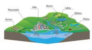
Topography means the shape of the land – whether it is flat, hilly, has water, or has forests.
Geography of Major Lagos Towns
Lagos Island:
- Land Type: A piece of land surrounded by water (an island)
- Water Bodies: Lagos Lagoon all around it
- Land Shape: Flat land, not hilly
- Special Features: Connected to mainland by bridges
Badagry:
- Land Type: Coastal area (close to the sea)
- Water Bodies: Atlantic Ocean, creeks, and lagoons
- Land Shape: Flat with some swampy areas
- Special Features: Sandy beaches, mangrove trees
Ikeja:
- Land Type: Mainland area
- Water Bodies: Small rivers and streams
- Land Shape: Mostly flat with gentle slopes
- Special Features: Good drainage, not swampy
Ikorodu:
- Land Type: Mainland close to lagoon
- Water Bodies: Ikorodu Lagoon, small rivers
- Land Shape: Flat with some hills
- Special Features: Good for both farming and fishing
Epe:
- Land Type: Peninsula (land almost surrounded by water)
- Water Bodies: Lekki Lagoon and creeks
- Land Shape: Low-lying and flat
- Special Features: Lots of fish, good for canoe travel
Common Geographic Features in Lagos:
- Flat Land: Most of Lagos is not hilly
- Lots of Water: Many lagoons, creeks, and rivers
- Coastal Location: Close to Atlantic Ocean
- Mangrove Forests: Special trees that grow in salty water
- Sandy Soil: Good for some crops, challenges for others
Why Geography Matters:
- Determines what jobs people can do (fishing, farming, trading)
- Affects how people travel (boats, bridges, roads)
- Influences what people eat (fish, farm crops)
- Affects what materials people use for building houses
Multiple Choice Exercise
- What is geography? a) The study of animals only b) The study of places on Earth c) The study of numbers d) The study of colors
- What does topography mean? a) The color of the land b) The shape of the land c) The taste of water d) The sound of wind
- What type of land is Lagos Island? a) A mountain b) A forest c) An island d) A desert
- Which town in Lagos is closest to the Atlantic Ocean? a) Ikeja b) Ikorodu c) Badagry d) Epe
- What are mangrove forests? a) Trees that grow in salty water b) Trees that grow in mountains c) Trees that grow in desert d) Trees that grow in snow
Answers: 1(b), 2(b), 3(c), 4(c), 5(a)
This term's Nigerian History topics
Basic 2 Second Term · 6 topics
Get Nigerian History as PDF and Word
Every week of Basic 2 Nigerian History, Second Term, formatted and ready to print. Ad-free, and the copy lock comes off.
Get this term Card, bank transfer, USSD or OPay
Basic 2 Nigerian History Lesson Notes for Other Topics
Major Towns In Lagos State
Read the full lesson note.
The Earliest Settlers Of The Major Towns In Lagos
Read the full lesson note.
Social And Political Development Of The Major Towns In Lagos
Read the full lesson note.
Heroes In Lagos State: Ogunfunminire, Kandido, Da Rocha e.t.c
Read the full lesson note.
Heroines In Lagos State : Madam Efunroye Tinubu And Others
Read the full lesson note.
Indigenous People Of Lagos State - Awori, Egun, Ijebu Etc.
Read the full lesson note.
Tradition And Origin People Of Awori, Ijebu, e.t.c
Read the full lesson note.

Location Of The Indigenous People Of Lagos State
Read the full lesson note.

Other Pre-Colonial Settlers In Lagos
Read the full lesson note.
Indigenous Occupation And Mode Of Transportation In Lagos
Read the full lesson note.

Nigerian People: South West And South-South
Read the full lesson note.
Nigerian People: South East And North Central
Read the full lesson note.

Nigerian People - North West And North East
Read the full lesson note.
History Of Lagos State
Read the full lesson note.
History Of Lagos State II
Read the full lesson note.
Lesson Notes for Other Classes
Basic 1 Lesson Note
The complete lesson note to guide your studies.

Basic 3 Lesson Note
The complete lesson note to guide your studies.
Basic 4 Lesson Note
The complete lesson note to guide your studies.
Basic 5 Lesson Note
The complete lesson note to guide your studies.
Basic 6 Lesson Note
The complete lesson note to guide your studies.
