The Early Regions in Nigeria Basic 4 Nigerian History Lesson Note
Download Lesson NoteTopic: The Early Regions in Nigeria
What is a Region?
A region is a large area of land with:
- Similar people and culture
- Same type of government
- Shared language or traditions
- Clear boundaries that separate it from other areas
Think of it like dividing Nigeria into big sections for easier management.
The Early Regions in Nigeria
- Northern Region
- Created: 1900
- Created by: British Colonial Government
- Capital: Kaduna
- Covered: All northern parts of Nigeria
- Main People: Hausa-Fulani
- Main Religion: Islam
- Southern Region
- Created: 1900
- Created by: British Colonial Government
- Later divided into:
- Western Region (1914)
- Eastern Region (1914)
After 1914 Division:
- Western Region
- Created: 1914
- Created by: Lord Lugard (British Governor)
- Capital: Ibadan
- Main People: Yoruba
- Main Religion: Christianity and Traditional
- Eastern Region
- Created: 1914
- Created by: Lord Lugard (British Governor)
- Capital: Enugu
- Main People: Igbo
- Main Religion: Christianity and Traditional
Reasons Why These Regions Were Created
- Easier Administration
- Nigeria was too big for one person to manage
- Different governors could handle each region
- Faster decision-making in smaller areas
- Cultural Differences
- Different ethnic groups lived in different areas
- Different languages and customs
- Different religions (Islam in North, Christianity in South)
- Economic Reasons
- Different products from different regions
- North: cotton, groundnuts, livestock
- West: cocoa, palm oil
- East: coal, palm oil, yam
- Better Control
- Divide and rule – British strategy
- Prevent unity among Nigerians
- Easier to control smaller groups
- Geographic Differences
- North: mostly savanna and desert
- South: mostly forest and coastal areas
- Different farming and lifestyle patterns
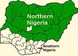
Location of These Regions on Map

Northern Region:
- Covered: All areas above the River Niger and Benue
- States today: Sokoto, Kano, Kaduna, Bauchi, Borno, and others
- Largest region by land area
Western Region:
- Covered: Southwest Nigeria
- States today: Lagos, Ogun, Oyo, Osun, Ondo, Ekiti
- Bordered: Atlantic Ocean to the south
Eastern Region:
- Covered: Southeast and parts of South-South Nigeria
- States today: Enugu, Anambra, Imo, Abia, Ebonyi, Cross River
- Bordered: Cameroon to the east
Exercises
- Fill in the blanks:
- A region is a _______ area of land with similar people
- The Northern Region was created in _______
- _______ created the Western and Eastern regions
- The Western Region’s capital was _______
- True or False:
- All regions were created in the same year ( )
- Lord Lugard created the regional divisions ( )
- Regions were created to make administration easier ( )
- All regions had the same culture ( )
- Match the region with its capital:
- Northern Region → Kaduna
- Western Region → Ibadan
- Eastern Region → Enugu
- Circle the reasons for creating regions:
- Easier administration
- To build more roads
- Cultural differences
- Economic reasons
- To plant more trees
- Better control
- Which region would you find these today?
- Lagos State → _______ Region
- Kano State → _______ Region
- Enugu State → _______ Region
- Put these events in order:
- ( ) Western and Eastern regions created
- ( ) Northern and Southern regions created
- ( ) Nigeria became independent
- ( ) Lord Lugard became Governor-General
- Short Answer:
- What does “region” mean?
- Who created the first regions in Nigeria?
- Why did the British divide Nigeria into regions?
- Which region was the largest by area?
- Map Exercise: Draw a simple map of Nigeria and label where the three main regions were located.
Answer Key:
- large, 1900, Lord Lugard, Ibadan
- False, True, True, False
- Matching as shown above
- Circle: Easier administration, Cultural differences, Economic reasons, Better control
- Western, Northern, Eastern
- 2, 1, 4, 3 (1900, 1914, 1960, 1914)
- Large area with similar people / British Colonial Government / Easier to manage and control / Northern Region
- Students should draw basic map with North, West, and East marked
First Term Nigerian History Lesson Notes for Other Topics
Other Pre-Colonial Settlers In Lagos
Explore lesson notes covering all topics.

Nigerian People - North West And North East
Explore lesson notes covering all topics.

Nigerian People: South East And North Central
Explore lesson notes covering all topics.
Nigerian People: South West And South-South
Explore lesson notes covering all topics.
Indigenous Occupation And Mode Of Transportation In Lagos
Explore lesson notes covering all topics.
Tradition And Origin People Of Awori, Ijebu, e.t.c
Explore lesson notes covering all topics.
Location Of The Indigenous People Of Lagos State
Explore lesson notes covering all topics.
Indigenous People Of Lagos State - Awori, Egun, Ijebu Etc.
Explore lesson notes covering all topics.

British Rule In Nigeria, Traditional Nationalism, And Resistances
Explore lesson notes covering all topics.
Detailed Study Of Major Constitutions
Explore lesson notes covering all topics.

Meaning Of A Constitution
Explore lesson notes covering all topics.

British Rule In Nigeria 3
Explore lesson notes covering all topics.
British Rule In Nigeria
Explore lesson notes covering all topics.
British Rule In Nigeria 2
Explore lesson notes covering all topics.

The Royal Niger Company
Explore lesson notes covering all topics.

Lesson Notes for Other Classes

Basic 2 Lesson Note
The complete lesson note to guide your studies.

Basic 3 Lesson Note
The complete lesson note to guide your studies.

Basic 5 Lesson Note
The complete lesson note to guide your studies.

JSS1 Lesson Note
The complete lesson note to guide your studies.

JSS2 Lesson Note
The complete lesson note to guide your studies.
JSS3 Lesson Note
The complete lesson note to guide your studies.