Principle of Elementary Surveying SS3 Geography Lesson Note
Download Lesson NoteTopic: Principle of Elementary Surveying
SPECIFIC OBJECTIVES: At the end of the lesson, pupils should be able to
- Explain surveying terms and describe surveying instruments
- State the uses of chain and prismatic compass in surveying
- Mention the procedures for plotting traverse
- Discuss ways of avoiding obstacles in the field
INSTRUCTIONAL TECHNIQUES:
- Identification,
- explanation,
- questions and answers,
- demonstration,
- videos from the source
INSTRUCTIONAL MATERIALS:
- Videos,
- loudspeaker,
- textbook,
- pictures
NOTE
PRINCIPLES OF ELEMENTARY SURVEYING
Surveying is the process of measuring and mapping the Earth’s surface to gather data about the shape, dimensions, and features of a particular area of land. It involves using various instruments and techniques to determine distances, angles, and elevations, creating accurate representations of terrain for purposes like construction, mapping, and land development.
Terms and Instruments Used in Surveying
Surveying involves several terms and instruments:
- Total Station: A precision instrument used for measuring angles and distances, combining a theodolite and an electronic distance metre.
- Theodolite: An optical instrument for measuring both horizontal and vertical angles, crucial for determining precise angles during surveys.
- Level: Used to determine height differences or elevations between points on the Earth’s surface.
- GPS (Global Positioning System): A satellite-based navigation system that allows surveyors to determine accurate positions on the Earth’s surface.
- Chain and Tape: Traditional tools for measuring distances on the ground, where a chain is a series of connected links, and a tape is a flexible measuring tape.
- Prism and Prism Pole: A prism reflects signals to a total station, helping measure distances accurately, while a prism pole holds the prism at a known height.
- Measuring Tape: Simple but effective for measuring distances on the ground. Steel or fibreglass tapes are common.
- Auto Level: An instrument that automatically levels itself, used for determining level points across a surveyed area.
- Ranging pole: A ranging pole is a simple yet essential tool used in surveying and mapping.
- Benchmark: A point with a precisely known elevation, used as a reference for measuring other elevations in a survey.
Uses of Chain and Prismatic Compass in Surveying
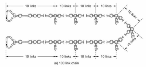
- Chain
The following are uses of chain in Surveying:
- The chain is used to measure distances on the ground. Chains come in various lengths, and they are stretched between two points to determine the distance.
- Chains are often used in traversing to measure the lengths of survey lines accurately.
- Prismatic Compass
The following are uses of prismatic compass in Surveying:
- A prismatic compass is used to measure magnetic bearings or directions. It helps in determining angles with respect to the magnetic north.
- Surveyors use the prismatic compass to establish a reference direction for their survey work.

Procedures for Plotting Traverse
Plotting a traverse involves representing surveyed lines and angles on a map or drawing. The following are the general procedures:
- Select a Scale: Choose an appropriate scale for the drawing. The scale determines the relationship between distances on the map and the actual distances on the ground.
- Draw a Baseline: Start by drawing a baseline that represents one of the measured survey lines. This can be a horizontal line along the bottom or another suitable orientation.
- Plot Angles: Use the measured angles from the traverse to plot the direction of the subsequent survey lines. This is typically done using a protractor or compass.
- Plot Distances: Using the chosen scale, measure and mark distances along the plotted lines to represent the lengths of the survey lines.
- Complete the Traverse: Continue plotting the angles and distances until the entire traverse is represented on the map.
- Check Closure: Ensure that the traverse forms a closed figure. If it doesn’t, adjustments may be needed to correct errors in measurements or plotting.
- Label Points: Label the points where the survey lines intersect. These points represent survey stations or locations.
Ways of avoiding obstacles in the field
Avoiding obstacles in the field is crucial for a smooth and accurate surveying process. Below are some ways to achieve this:
- Pre-survey Site Visit: Conduct a pre-survey site visit to identify potential obstacles such as buildings, trees, or other structures.
- Use Aerial Imagery: Utilise satellite imagery or aerial photographs to gain insights into the terrain and identify potential obstacles.
- Communication with Landowners: Communicate with landowners or property managers to gather information about any potential obstacles on the site.
- GPS and GIS Technologies: Employ GPS and GIS technologies to map out the survey area accurately. These tools can help in planning the survey layout while considering existing obstacles.
- Use Remote Sensing Tools: Implement remote sensing tools, such as LiDAR or ground-penetrating radar, to detect underground obstacles or topographical features that might affect the survey.
- Implement Safety Protocols: Prioritise safety by establishing protocols for dealing with unexpected obstacles during fieldwork. This includes having appropriate safety equipment and contingency plans.
EVALUATION:
- What is Surveying?
- Mention 5 common instruments used for Surveying.
- Mention 5 ways of avoiding obstacles in the field
- Identify 2 uses of prismatic compass in Surveying.
CLASSWORK: As in evaluation
CONCLUSION: The teacher commends the students positively

Second Term Geography Lesson Notes for Other Topics
Map Readings
Explore lesson notes covering all topics.

Representation of Relief Form
Explore lesson notes covering all topics.

Mining in Africa (Copper, Gold, and Petroleum)
Explore lesson notes covering all topics.

Bush Fallowing in West Africa
Explore lesson notes covering all topics.
GIS Application
Explore lesson notes covering all topics.

Soil
Explore lesson notes covering all topics.

Geo- Political Issues (Land Reclamation)
Explore lesson notes covering all topics.

World Population II
Explore lesson notes covering all topics.

Settlement
Explore lesson notes covering all topics.

World Population I
Explore lesson notes covering all topics.
Transportation In Nigeria
Explore lesson notes covering all topics.

Commercial Activities In Nigeria
Explore lesson notes covering all topics.

Manufacturing Companies In Nigeria
Explore lesson notes covering all topics.

Environmental Conservation
Explore lesson notes covering all topics.

Agriculture in Nigeria
Explore lesson notes covering all topics.

Lesson Notes for Other Classes

JSS1 Lesson Note
The complete lesson note to guide your studies.

JSS2 Lesson Note
The complete lesson note to guide your studies.

SS1 Lesson Note
The complete lesson note to guide your studies.

SS2 Lesson Note
The complete lesson note to guide your studies.