Karst (Limestone) Topography SS3 Geography Lesson Note
Download Lesson NoteTopic: Karst (Limestone) Topography
SPECIFIC OBJECTIVES: At the end of the lesson, pupils should be able to
- Explain the meaning of Karst/Limestone topography and identify Karst regions in Nigeria and the world
- State the characteristics of Karst topography
- Describe the surface and underground features of the Karst regions
- Dissect the importance of Karst regions to man
INSTRUCTIONAL TECHNIQUES:
- Identification,
- explanation,
- questions and answers,
- demonstration,
- videos from the source
INSTRUCTIONAL MATERIALS:
- Videos,
- loudspeaker,
- textbook,
- pictures
NOTE
KARST (LIMESTONE) TOPOGRAPHY
Karst topography, often associated with limestone bedrock, is characterised by unique landforms created by the dissolution of soluble rocks, particularly limestone and dolomite. It is shaped by the process of chemical weathering, where rainwater, containing carbon dioxide, forms a weak carbonic acid that gradually dissolves the soluble rock.
Formation: Over time, as water percolates through the limestone, it enlarges underground cavities, creating a network of interconnected voids. This subsurface drainage often results in the collapse of overlying rock, forming sinkholes and surface depressions.
Karst Regions in Nigeria
In Nigeria, limestone deposits at Ewekoro(Ogun State), Sagamu(Ogun), Nkalagu(Ebonyi), Gboko(Benue State), Calabar, and Sokoto are used for the cement industries.
Karst Regions Worldwide
Karsts are found in widely scattered sections of the world, including the Causes of France; the Kwangsi area of China; the Yucatán Peninsula; and the Middle West, Kentucky, and Florida in the United States.
Characteristics of Karst topography
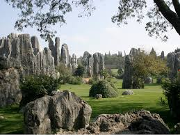
Karst topography is characterised by distinctive landforms resulting from the dissolution of soluble rocks, typically limestone or dolomite. Key features include sinkholes, caves, disappearing streams, and underground drainage systems. The terrain often exhibits irregular landscapes with unique geological formations shaped by the dissolution of rock over time.
Surface Features of Karst Regions
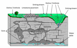
- Sinkholes: Depressions in the ground formed when underground caverns collapse, creating visible holes on the surface.
- Poljes: Large, flat-floored depressions surrounded by hills or mountains, often serving as catchment areas for water.
- Dolines: Smaller depressions, similar to sinkholes, but usually with vegetation or water at the bottom.
- Uvalas: Expanded depressions formed by the merging of lines.
Underground Features of Karst Regions:
- Caves: Extensive underground systems created by the dissolution of soluble rocks, offering unique habitats.
- Subterranean Rivers: Underground watercourses flowing through caves or passages, contributing to the shaping of the landscape.
- Speleothems: Formations such as stalactites and stalagmites resulting from the deposition of minerals in caves.
Importance of Karst Regions to Man
- Karst regions often act as important water reservoirs, supplying freshwater through underground aquifers.
- Unique ecosystems in caves and surface features support diverse flora and fauna, including rare and specialised species.
- Karst landscapes attract tourists due to their intriguing geological formations, caves, and scenic beauty, contributing to local economies.
- Many caves in karst regions have historical and cultural significance, containing artefacts and ancient rock art.
- The fertile soils in sinkholes and dolines are suitable for agriculture, providing opportunities for farming in these regions.
EVALUATION:
- What is Karst’s topography?
- Identify 3 surface features and 3 underground features of Karst regions.
- Describe the formation of Karst
- Mention 5 importance of Karst regions to Man
CLASSWORK: As in evaluation
CONCLUSION: The teacher commends the students positively

First Term Geography Lesson Notes for Other Topics

Rocks
Explore lesson notes covering all topics.

Mountains
Explore lesson notes covering all topics.

Lowlands
Explore lesson notes covering all topics.

The Environment - Ecosystem & Its Component
Explore lesson notes covering all topics.

Geography: An Introduction
Explore lesson notes covering all topics.

The Earth's Structure
Explore lesson notes covering all topics.

Latitude & Longitude
Explore lesson notes covering all topics.

The Earth's Revolution
Explore lesson notes covering all topics.
The Earth's Rotation
Explore lesson notes covering all topics.

Satellite Remote Sensing
Explore lesson notes covering all topics.

Tourism
Explore lesson notes covering all topics.

World Trade
Explore lesson notes covering all topics.

ECOWAS
Explore lesson notes covering all topics.

Climatic Change
Explore lesson notes covering all topics.

Mass Movements
Explore lesson notes covering all topics.

Lesson Notes for Other Classes

JSS1 Lesson Note
The complete lesson note to guide your studies.

JSS2 Lesson Note
The complete lesson note to guide your studies.

SS1 Lesson Note
The complete lesson note to guide your studies.

SS2 Lesson Note
The complete lesson note to guide your studies.