Semi-Guinea Savannah, Niger, Benue Confluence, Middle Belt Zone In Nigeria SS3 Nigerian History Lesson Note
Download Lesson NoteTopic: Semi-Guinea Savannah, Niger, Benue Confluence, Middle Belt Zone In Nigeria
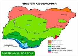
Nigeria has many different types of land and climate zones. One important area is the middle part of Nigeria, which includes the Semi-Guinea Savannah, the place where Rivers Niger and Benue meet (called the Niger-Benue Confluence), and the wider region known as the Middle Belt. This lesson will help us learn about this area – what it looks like, the people who live there, and how they use the land.
The Semi-Guinea Savannah Zone
What is the Semi-Guinea Savannah?
The Semi-Guinea Savannah is a type of land that has both grassland and scattered trees. It is between the drier Sudan Savannah in the north and the wetter rainforest in the south. This zone gets more rain than the Sudan Savannah but less than the rainforest.
Location
The Semi-Guinea Savannah stretches across the middle of Nigeria, covering parts of these states:
- Kwara
- Niger
- Kogi
- Nasarawa
- Benue
- Taraba
- Adamawa
- Southern parts of Kaduna
- Southern parts of Plateau
- Northern parts of Enugu
- Northern parts of Cross River
Climate
- Rainfall: Between 1,000-1,500mm per year
- Rainy season: April to October (about 6-7 months)
- Dry season: November to March (about 5-6 months)
- Temperature: Generally warm (average 26°C or 79°F)
Vegetation
- Grasses that can grow up to 3 meters tall
- Scattered trees that are taller and more numerous than in the Sudan Savannah
- Common trees include: locust bean, shea butter, mahogany, and baobab
- Trees often lose their leaves during the dry season
- There are more trees near rivers and streams
Land Features
- Gently rolling plains and plateaus
- Rocky outcrops in some areas, especially in Plateau State
- Fertile soils suitable for farming
- Many rivers and streams that flow into the Niger and Benue rivers
The Niger-Benue Confluence
What is the Niger-Benue Confluence?
The Niger-Benue Confluence is the place where Nigeria’s two largest rivers, the River Niger and the River Benue, meet and join together. This meeting point creates a Y-shaped pattern on the map. After joining, the combined river continues southward to the Niger Delta and then into the Atlantic Ocean.
Location
The confluence is located at Lokoja, the capital of Kogi State. This location has been important throughout Nigeria’s history.
Importance of the Confluence
- Transportation: Rivers provide natural highways for boats and canoes
- Fertile Land: The area around the confluence has rich soil from river deposits
- Fishing: The meeting of the rivers creates good fishing grounds
- Historical Significance: Lokoja was the first capital of colonial Nigeria
- Cultural Crossroads: Many different ethnic groups have settled near the confluence
- Strategic Value: Controls movement between northern and southern Nigeria
Physical Features Around the Confluence
- Mount Patti: A hill overlooking Lokoja and the confluence
- Floodplains: Flat areas near the rivers that flood seasonally
- River Islands: Small islands formed by river deposits
- Wetlands: Marshy areas that support diverse wildlife
The Middle Belt Zone
What is the Middle Belt?
The Middle Belt is a wider geographical and cultural zone that runs across the center of Nigeria. It’s called the “Middle Belt” because it lies between the predominantly Muslim north and the predominantly Christian south. The Semi-Guinea Savannah and Niger-Benue Confluence are part of this larger Middle Belt region.
States in the Middle Belt
The Middle Belt generally includes these states:
- Kwara
- Kogi
- Niger
- Nasarawa
- Benue
- Plateau
- Taraba
- Federal Capital Territory (Abuja)
- Parts of Adamawa
- Parts of Kaduna
Ethnic Diversity
The Middle Belt is home to many different ethnic groups. Some of the major groups include:
- Tiv
- Idoma
- Igala
- Ebira
- Nupe
- Gwari (Gbagyi)
- Berom
- Angas
- Jukun
- Chamba
- Tarok
- Middle Belt Fulani
Unlike the northern and southern parts of Nigeria, which have more dominant ethnic groups (Hausa-Fulani in the north, Yoruba in the southwest, Igbo in the southeast), the Middle Belt has dozens of distinct ethnic groups, each with their own language and traditions.
Cultural Features
- Religious Diversity: Mix of Christianity, Islam, and traditional religious practices
- Languages: Many different languages are spoken, often within short distances
- Traditional Leadership: Each ethnic group has its own traditional leadership structures
- Festivals: Rich cultural celebrations, often tied to farming cycles
- Crafts: Distinctive pottery, weaving, and wood carving traditions
Livelihoods and Economic Activities
Farming
Agriculture is the main economic activity in the Semi-Guinea Savannah and Middle Belt:
- Main Food Crops: Yams, cassava, maize, guinea corn, millet, beans, groundnuts
- Cash Crops: Sesame seeds, soybeans, cotton, ginger, cashew nuts
- Farming Methods: Both traditional and modern methods are used
- Challenges: Irregular rainfall, soil erosion, farmer-herder conflicts
Livestock Rearing
- Cattle, goats, sheep, and poultry are common
- Both settled farmers and nomadic herders raise animals
- The region is a meeting point between northern cattle herders and southern farmers
Fishing
- Important in communities along the Niger and Benue rivers
- Both traditional and modern fishing methods are used
- Fish are often dried or smoked for preservation
Mining
The Middle Belt is rich in minerals:
- Tin and Columbite: Mined on the Jos Plateau
- Iron Ore: Found in Kogi State
- Coal: Mined in northern Enugu
- Limestone: Used for cement production in several states
- Precious Stones: Including sapphires and topaz
Trading
- Markets serve as important meeting points between northern and southern traders
- Agricultural products are major trade items
- Cross-border trade with neighboring countries
Settlements and Housing
Types of Settlements
- Rural Villages: Usually organized by ethnic group or clan
- Market Towns: Centers for trading between different communities
- Administrative Centers: State and local government headquarters
- Mining Settlements: Communities that developed around mining activities
Traditional Housing
Housing styles vary by ethnic group and available materials:
- Compound Houses: Multiple buildings arranged around a courtyard
- Building Materials: Mud, grass thatch, wood, and increasingly cement blocks
- Designs: Reflect local traditions and climate adaptation
Modern Developments
- Growing urban centers with modern buildings
- Abuja, Nigeria’s capital city, is located in the Middle Belt
- Infrastructure development like roads, electricity, and water systems
Environmental Challenges
Deforestation
- Clearing of trees for farmland, firewood, and timber
- Loss of wildlife habitats
- Soil erosion and desertification
Soil Erosion
- Especially severe in hilly areas
- Caused by heavy rainfall, poor farming practices, and deforestation
- Leads to loss of fertile topsoil
Flooding
- Seasonal flooding along the Niger and Benue rivers
- Can destroy crops, homes, and infrastructure
- Climate change is making floods more severe and unpredictable
Land Disputes
- Conflicts between farmers and herders over land use
- Competition for fertile land and water resources
- Historical and ongoing ethnic tensions over territory
Historical and Cultural Significance
Historical Role
- Pre-Colonial Period: Home to various kingdoms and chiefdoms
- Colonial Period: Early European contact along the rivers
- Missionary Activity: Many Christian missions established in the region
- Independence Era: Important in Nigeria’s political development
Cultural Heritage
- Archaeological Sites: Ancient settlements and artifacts
- Traditional Crafts: Pottery, weaving, carving, and metalwork
- Performance Arts: Rich traditions of music, dance, and storytelling
- Festivals: Harvest celebrations, initiation ceremonies, and religious festivals
Tourism Potential
- Scenic landscapes including hills, rivers, and waterfalls
- Wildlife in protected areas
- Cultural tourism based on festivals and crafts
- Historical sites including colonial buildings
Modern Developments and Changes
Urbanization
- Growth of cities and towns
- Rural-to-urban migration
- Changing lifestyles and occupations
Education
- Increase in schools and universities
- Growing literacy rates
- Blending of traditional and modern knowledge
Infrastructure
- Road networks connecting previously isolated areas
- Telecommunications expanding to rural communities
- Electricity and water supply improvements
Cultural Change
- Influences from other parts of Nigeria and beyond
- New religions and belief systems
- Changing family structures and gender roles
The Middle Belt in Nigeria’s National Context
Political Importance
- Strategic location between north and south
- Home to Nigeria’s capital city (Abuja)
- Politically diverse region
Economic Contribution
- Agricultural production
- Mineral resources
- Transportation corridor
Cultural Role
- Bridge between northern and southern cultures
- Contributor to Nigeria’s cultural diversity
- Keeper of many traditional practices and languages
Conclusion
The Semi-Guinea Savannah, Niger-Benue Confluence, and Middle Belt Zone form an important region in Nigeria. With its diverse landscapes, peoples, and cultures, this area serves as a bridge between Nigeria’s north and south. The region faces many challenges but also has significant potential for development based on its natural resources, agricultural productivity, and cultural heritage.
Evaluation Questions
- What are the main features of the Semi-Guinea Savannah vegetation?
- Why is the Niger-Benue Confluence important in Nigeria?
- Name five ethnic groups found in the Middle Belt.
- What are the main economic activities in the Middle Belt region?
- Describe two environmental challenges facing the Semi-Guinea Savannah zone.
Classwork
Answer the following questions:
- Describe the location and climate of the Semi-Guinea Savannah.
- Why is the Middle Belt called a “cultural bridge” in Nigeria?
- List three crops that grow well in the Middle Belt and explain why.
- What minerals are found in the Middle Belt region?
- How has the Niger-Benue Confluence shaped settlement patterns in central Nigeria?

First Term Nigerian History Lesson Notes for Other Topics
Military Counter Coup July 1966 Second Military Regime: The Emergence Of Yakubu Gowon
Explore lesson notes covering all topics.
First Military Regime In Nigeria : Major General J.T.U Aguyi Ironsi 1966.
Explore lesson notes covering all topics.
Military Intervention In Nigerian Politics: First Coup D'Etat January 15, 1966
Explore lesson notes covering all topics.
First Democratic Civilian Government In Nigeria 1960-1966
Explore lesson notes covering all topics.

Constitutional Development In Nigeria: Road To Independence
Explore lesson notes covering all topics.
Nationalism And National Movement In Nigeria
Explore lesson notes covering all topics.
British Colonial Economy Social Development & Inter Group Relations In Nigeria
Explore lesson notes covering all topics.

British Colonial Political Administration In Nigeria: Indirect Rule System
Explore lesson notes covering all topics.
Amalgamation Of Nigeria And Impact
Explore lesson notes covering all topics.
Relationship Between People From Different Centers Of Civilization In Precolonial Nigeria: Kanem Bornu/Hausa Empire
Explore lesson notes covering all topics.
Relationship Between People From Different Centers Of Civilization In Precolonial Nigeria: Igbo/Ibibio
Explore lesson notes covering all topics.

Relationship Between People From Different Centers Of Civilization In Precolonial Nigeria: Igbo/Niger Delta City States
Explore lesson notes covering all topics.

Relationship Between People From Different Centres Of Civilization In Precolonial Nigeria: Ife/Benin
Explore lesson notes covering all topics.
Non-Centralized States: The Idoma
Explore lesson notes covering all topics.

Non-Centralized States: The Igbo
Explore lesson notes covering all topics.

Lesson Notes for Other Classes

JSS1 Lesson Note
The complete lesson note to guide your studies.

JSS2 Lesson Note
The complete lesson note to guide your studies.

SS1 Lesson Note
The complete lesson note to guide your studies.

SS2 Lesson Note
The complete lesson note to guide your studies.