Nigeria: Location And Position SS1 Geography Lesson Note
Download Lesson NoteTopic: Nigeria: Location And Position
LOCATION: Nigeria is located between 4°N and 14°N of the Equator, and between 3°E and 15°E of the Greenwich Meridian.
Note that since Nigeria is located between Latitudes 4°N and 14°N, the latitudinal extent of Nigeria is 10° i.e. 15° 4^°, while her longitudinal extent is 12° i.e. 15° 3°
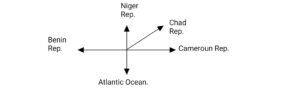
POSITION: The position of Nigeria refers to the intended eras in Africa (West Africa). She is bounded in the North by Niger Republic, in the North-East Chadublic, in the East by Cameroon Republic, in the South by the Anticc Ocean, and west by Benin Republic. Nigeria is bounded by French-speaking (Francophone) West African countries.
SIZE: Nigeria is the fourth largest country in West Africa in terms of land area after Niger Republic, Mali and Mauritania. The total land area of Nigeria is approximately 923, 768 sq km. The greatest distance from east to west is approximately 1,300 km while from north to south is about 1,100 km. In terms of population, Nigeria is the most populous single country in Africa with a population of over 140 million according to the 2006 population census. Hence, she is often referred to as The Giant of Africa.
POLITICAL DIVISION
Nigeria came into existence in 1914 when the Northern and Southern protectorates were amalgamated; she had her independence in 1960, precisely prior time, Nigeria was governed by colonial masters which included
| SN | NAME | YEARS RULED |
| 1 | Sir Fredrick Lord Lugard | 1912 – 1919 |
| 2 | Sir Hurge Clifford | 1919 – 1925 |
| 3 | Sir Creamer Thompson | 1925 – 1931 |
| 4 | Sir Donald Cameroon | 1931 – 1935 |
| 5 | Sir Bernard Boundillion | 1935 – 1943 |
| 6 | Sir Anthony Richard | 1943 – 1948 |
| 7 | Sir John McPherson | 1948 – 1958 |
| 8 | Sir James Robertson | 1958 – 1960 |
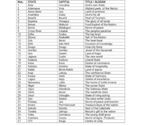
Nigeria politically is divided into 36 States with the FCT. Each of the States has a slogan or title which can also be used for identifying the state.
The States include the following:-

Second Term Geography Lesson Notes for Other Topics

Map Readings
Explore lesson notes covering all topics.
Representation of Relief Form
Explore lesson notes covering all topics.

Principle of Elementary Surveying
Explore lesson notes covering all topics.
Mining in Africa (Copper, Gold, and Petroleum)
Explore lesson notes covering all topics.
Bush Fallowing in West Africa
Explore lesson notes covering all topics.
GIS Application
Explore lesson notes covering all topics.
Soil
Explore lesson notes covering all topics.
Geo- Political Issues (Land Reclamation)
Explore lesson notes covering all topics.
World Population II
Explore lesson notes covering all topics.
Settlement
Explore lesson notes covering all topics.
World Population I
Explore lesson notes covering all topics.
Transportation In Nigeria
Explore lesson notes covering all topics.
Commercial Activities In Nigeria
Explore lesson notes covering all topics.

Manufacturing Companies In Nigeria
Explore lesson notes covering all topics.

Environmental Conservation
Explore lesson notes covering all topics.


Lesson Notes for Other Classes

JSS1 Lesson Note
The complete lesson note to guide your studies.
JSS2 Lesson Note
The complete lesson note to guide your studies.

SS2 Lesson Note
The complete lesson note to guide your studies.

SS3 Lesson Note
The complete lesson note to guide your studies.