Land And People Of Nigeria SS3 Nigerian History Lesson Note
Download Lesson NoteTopic: Land And People Of Nigeria
Nigeria is a large country in West Africa with many different types of land, climate, and people. The way the land is shaped affects how people live, what food they grow, and what work they do. This lesson will help us understand Nigeria’s different geographical zones and how these zones influence the daily lives of Nigerians.
Brief History of Nigeria
Nigeria has a rich and complex history that spans thousands of years. Before it became a country, the area that is now Nigeria was home to many powerful kingdoms and empires.
Some of the ancient kingdoms and empires included:
- The Nok Civilization (around 500 BCE – 200 CE)
- The Kanem-Bornu Empire (9th century – 19th century)
- The Benin Kingdom (13th century – 19th century)
- The Oyo Empire (14th century – 19th century)
- The Sokoto Caliphate (19th century)
In the late 19th century, the British began to take control of the area. By 1914, the British joined the Northern and Southern Protectorates to create what we now call Nigeria.
Nigeria gained its independence from Britain on October 1, 1960. Since then, Nigeria has experienced both civilian and military rule. Today, Nigeria is a democratic country with a federal system of government.
Nigeria is Africa’s most populous country with over 200 million people. It has more than 250 ethnic groups, with the largest being Hausa, Yoruba, and Igbo. The country is rich in natural resources, especially oil, which was discovered in the late 1950s.
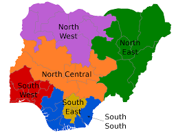
Nigeria’s Six Geographical Zones
Nigeria is typically divided into six geographical zones: North Central, North East, North West, South East, South-South, and South West. Each zone has distinct characteristics in terms of climate, vegetation, and cultural practices.
- North Central Zone
States: Benue, Kogi, Kwara, Nasarawa, Niger, Plateau, and the Federal Capital Territory (Abuja)
Physical Features:
- Mostly plateau and highland areas
- Rivers Niger and Benue meet in this zone
- Savanna grassland vegetation
- Moderate rainfall (about 1,000-1,500mm yearly)
Cultural and Economic Activities:
- Farming of crops like yam, cassava, maize, and rice
- Livestock rearing, especially cattle
- Mining of tin (especially in Plateau State)
- Trading and civil service
- North East Zone
States: Adamawa, Bauchi, Borno, Gombe, Taraba, and Yobe
Physical Features:
- Mountainous areas in parts of Adamawa and Taraba
- Lake Chad basin in Borno
- Sahel savanna in the northern parts
- Sudan savanna in the southern parts
- Low rainfall (about 500-1,000mm yearly)
Cultural and Economic Activities:
- Cattle herding and livestock rearing
- Farming of sorghum, millet, and groundnuts
- Fishing in Lake Chad
- Trading across borders with neighboring countries
- North West Zone
States: Jigawa, Kaduna, Kano, Katsina, Kebbi, Sokoto, and Zamfara
Physical Features:
- Mainly flat plains
- Sudan savanna and Sahel savanna vegetation
- Low rainfall (about 500-1,000mm yearly)
- River Kaduna and parts of River Niger flow through this zone
Cultural and Economic Activities:
- Extensive farming of millet, sorghum, and cotton
- Livestock rearing, especially cattle
- Trading and commerce (Kano is a major trading center)
- Traditional crafts like leather work and weaving
- South East Zone
States: Abia, Anambra, Ebonyi, Enugu, and Imo
Physical Features:
- Hills and valleys in many areas
- Tropical rainforest vegetation, though much has been cleared
- High rainfall (about 1,500-2,500mm yearly)
- Erosion problems in many areas
Cultural and Economic Activities:
- Intensive farming of yam, cassava, and palm oil
- Trading and commerce
- Small-scale manufacturing
- Coal mining (especially in Enugu)
- South-South Zone
States: Akwa Ibom, Bayelsa, Cross River, Delta, Edo, and Rivers
Physical Features:
- Niger Delta region with many rivers and creeks
- Mangrove swamps along the coast
- Rainforest in inland areas
- Very high rainfall (over 2,500mm yearly in some areas)
Cultural and Economic Activities:
- Oil and gas production (Nigeria’s main source of income)
- Fishing and water transportation
- Farming of cassava, yam, and plantain
- Rubber and timber production
- South West Zone
States: Ekiti, Lagos, Ogun, Ondo, Osun, and Oyo
Physical Features:
- Coastal plains along Lagos and parts of Ogun and Ondo
- Rainforest vegetation in most areas
- High rainfall (about 1,500-2,000mm yearly)
- Ogun and Osun rivers flow through this zone
Cultural and Economic Activities:
- Farming of cocoa, kolanut, and food crops
- Industrial manufacturing, especially in Lagos
- Trading and commerce
- Service industries and tourism
Impact of Geography on People’s Activities
Geography plays a significant role in shaping the livelihoods and activities of Nigeria’s people. The natural environment affects what people can do and how they live in many important ways.
- Agriculture and Food Production
Different geographical zones support different types of farming:
- Northern regions (North West, North East): The drier climate is suitable for growing drought-resistant crops like millet, sorghum, and groundnuts. People also raise livestock like cattle, sheep, and goats because there is more open grazing land.
- Middle Belt (North Central): The moderate rainfall supports crops like yam, maize, and rice. Both farming and livestock rearing are common here.
- Southern regions (South West, South East, South-South): The heavy rainfall supports crops like cassava, cocoa, oil palm, and rubber. Fishing is important in coastal areas and along rivers.
- Natural Resources and Economic Activities
The availability of natural resources influences economic activities:
- Oil and Gas: Found mainly in the South-South zone, especially in the Niger Delta. This has led to the development of oil industries, refineries, and related businesses.
- Solid Minerals: Tin is mined in Plateau State (North Central), coal in Enugu (South East), and limestone in many parts of the country for cement production.
- Forests: The rainforests in the southern zones provide timber for construction and furniture-making.
- Water Bodies: Rivers, lakes, and the ocean support fishing communities and provide transportation routes.
- Transportation and Communication
The terrain affects how people and goods move around:
- Coastal Areas: Water transportation is common in the Niger Delta and along the coast.
- Hilly Regions: Building roads and railways is more difficult and expensive in places like parts of the South East and North Central zones.
- Desert and Semi-Desert Areas: Transportation networks are sparse in the extreme northern parts due to harsh conditions.
- River Systems: The Niger and Benue rivers have historically served as important transportation routes.
- Settlement Patterns
Where people choose to live is influenced by geography:
- Urban Centers: Major cities often developed at trade junctions, river crossings, or coastal areas with natural harbors (like Lagos).
- Rural Settlements: Villages are often located near water sources or in areas with fertile soil.
- Population Density: More people live in areas with better rainfall and soil fertility, making the southern zones generally more densely populated than the northern zones.
- Cultural Practices and Lifestyles
Geography has shaped cultural traditions over time:
- Housing Styles: In hot, dry northern areas, houses traditionally have thick walls and small windows to keep cool. In rainforest areas, houses often have large roofs to protect from heavy rains.
- Clothing: Traditional clothing varies from the lightweight materials in the hot, humid south to the heavier, more covering garments in the cooler, drier north.
- Festivals and Celebrations: Many cultural festivals are tied to agricultural cycles, which differ by geographical zone.
- Environmental Challenges
Different zones face different environmental problems:
- Coastal Areas: Face erosion, flooding, and rising sea levels, especially in the Niger Delta and Lagos areas.
- Northern Regions: Experience desertification, as the Sahara Desert slowly expands southward.
- South East: Suffers from severe gully erosion that destroys farmland and buildings.
- Urban Areas: Face pollution, waste management issues, and pressure on water resources.
How Geography Shapes Nigeria’s Future
Nigeria’s diverse geography presents both opportunities and challenges:
Opportunities:
- Agricultural diversity allows for growing many different crops
- Various natural resources can support economic development
- Different climates can attract tourism to experience various landscapes
Challenges:
- Climate change is affecting rainfall patterns and crop yields
- Environmental degradation threatens livelihoods
- Infrastructure development is difficult in some terrains
- Managing resources fairly across different zones
Evaluation
- Briefly discuss the history of Nigeria.
- Identify the 6 Geographical zones in Nigeria.
- Describe the impact of geography on the people’s activities.
Classwork
- Briefly discuss the history of Nigeria.
- Identify the 6 Geographical zones in Nigeria.
- Describe the impact of geography on the people’s activities.
Conclusion
The teacher commends the students positively for their attention and participation. The teacher reminds students that understanding Nigeria’s geography helps us appreciate the diversity of our country and how the natural environment shapes our lives and livelihoods. By knowing about the different geographical zones, we can better understand the challenges and opportunities facing different parts of Nigeria.
Assignment
- Draw a map of Nigeria showing the six geographical zones using different colors.
- Choose one geographical zone and write a short essay describing how the geography of that zone affects the way people live there.
- Explain three ways in which climate change might affect Nigeria’s different geographical zones in the future.


Lesson Notes for Other Classes

JSS1 Lesson Note
The complete lesson note to guide your studies.

JSS2 Lesson Note
The complete lesson note to guide your studies.

SS1 Lesson Note
The complete lesson note to guide your studies.

SS2 Lesson Note
The complete lesson note to guide your studies.