Basic Concepts And Component Of GIS SS1 Geography Lesson Note
Download Lesson NoteTopic: Basic Concepts And Component Of GIS
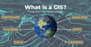
A geographic information system (GIS) is a system designed to capture, store, manipulate, analyze, manage, and present all types of spatial or geographical data.
The acronym GIS is sometimes used for Geographical Information Science or Geospatial Information Studies to refer to the academic discipline or career of working with geographic information systems and is a large domain within the broader academic discipline of Geoinformatics.
In general, GIS describes any information system that integrates, stores, edits, analyzes, shares, and displays geographic information. GIS applications are tools that allow users to create interactive queries (user-created searches), analyze spatial information, edit data in maps, and present the results of all these operations. Geographic information science is the science underlying geographic concepts, applications, and systems.
SOURCES OF GEOGRAPHIC DATA
- Satellite images
- Existing maps
- Land survey
- Socio-economic statistical records
- Aerial photographs
- Fieldwork or survey
COMPONENTS OF GIS
Geographic Information System has five key components which are:
- Hardware e.g keyboard, CPU, mouse, hard disk e.t.c
- Software e.g Microsoft Word, Corel Draw, Microsoft Excel, computer games e.t.c
- Data
- People: these are the people who design and maintain the system and they also develop plans for applying it.
- Method: A successful GIS operates according to a well-designed plan and business rules.

Third Term Geography Lesson Notes for Other Topics
Hydrosphere (Oceanic Basins)
Explore lesson notes covering all topics.
Earthquakes
Explore lesson notes covering all topics.

Fruit Farming In The Mediterranean Regions Of Africa
Explore lesson notes covering all topics.
Irrigation Agriculture In Nile Basin And The Niger Basin
Explore lesson notes covering all topics.
Climate And Vegetation
Explore lesson notes covering all topics.
Location, Size, Position And Political Division Of Africa
Explore lesson notes covering all topics.
Geographic Information System (GIS)
Explore lesson notes covering all topics.
Africa: Relief And Drainage
Explore lesson notes covering all topics.
Nigeria: Transportation
Explore lesson notes covering all topics.
Nigeria: Communication
Explore lesson notes covering all topics.

Manufacturing Industries In Nigeria
Explore lesson notes covering all topics.
Nigeria: Commercial Activities
Explore lesson notes covering all topics.
ECOWAS
Explore lesson notes covering all topics.
Map Reading And Measurements Of Distances On Maps
Explore lesson notes covering all topics.
Conventional Symbols Direction And Bearing
Explore lesson notes covering all topics.

Lesson Notes for Other Classes
JSS1 Lesson Note
The complete lesson note to guide your studies.
JSS2 Lesson Note
The complete lesson note to guide your studies.

SS2 Lesson Note
The complete lesson note to guide your studies.

SS3 Lesson Note
The complete lesson note to guide your studies.